Fallowfield Loop
The Fallowfield Loop is an off-road cycle path, pedestrian and horse riding route in the south of Manchester, England, which is one of the National Cycle Network routes and paths developed and built by Sustrans (it forms part of routes 6 and 60).[1]
.jpg)
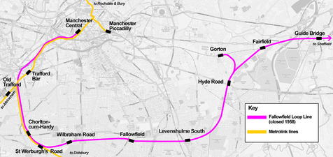
The Loop follows the route of the former Fallowfield Loop railway line, which was closed in October 1988. It is approximately 8 miles long and connects Chorlton-cum-Hardy in the west with Fairfield in the east, and passes through Whalley Range, Fallowfield, Levenshulme and Gorton. It can be seen on Google Maps where it is marked in the same way as a railway line,[2] and passes a short way above the "Fallowfield" marker.
History

The Fallowfield Loop railway line was a local railway route in Greater Manchester. Trains on the Manchester, Sheffield and Lincolnshire Railway line (later, the Great Central Railway line) from Sheffield Victoria and Guide Bridge used the "Loop" to access Manchester Central railway station.[3] At Chorlton-cum-Hardy the line joined with the Manchester South District Line on the route into Manchester Central.[4]
The Fallowfield Loop Line was fully opened to passengers in 1892. On 7 July 1958 the stations at Hyde Road, Levenshulme South, Fallowfield and Wilbraham Road were closed, although the line itself remained open to through passenger services until 5 May 1969, after which it was operated as a freight-only route. The loop line also provided access to Reddish Electric Depot, which was built adjacent to the line in 1954 to maintain the new fleet of electric trains for the Woodhead Line; the depot closed in 1983.[3] In March 1987 a short section of track at the former site of Hyde Road station was briefly used to give a public demonstration of the proposed Manchester Metrolink tram system, with a temporary station named Debdale Park constructed beside the line. Soon after this, the line was finally closed and the railway tracks were lifted in October 1988.[3]
Conversion to a cycle route
.jpg)
The old line had lain derelict for many years until the late 1990s, when a group of cyclists started campaigning for its conversion to a traffic free "greenway" across south Manchester. That group, together with supporters from local civic societies and other community groups, formally became the Friends of the Fallowfield Loop in June 2001. The route is now mostly owned by Sustrans, a charity which specialises in building off-road cycle routes.[5]
There are many access points onto the Loop along its length from Wilbraham Road in Chorlton-cum-Hardy to Fairfield Station at the eastern end. There are also several metal barriers along the route, which until late 2016 would disrupt the ride for cyclists on normal-size bikes, and larger cycles like tandems and trikes had to be lifted. However, after a successful trial period in 2016 the barriers along the route itself are now permanently open. The barriers at the different entrance points to the Loop are a variety of designs. Some of these are still very difficult to access using a normal bicycle, whilst others have been modified to be fully accessible even for tandems.
Along the route

The Fallowfield Loop forms a green structure in an arc around Manchester city centre, linking parks and open spaces. Near its western end the Loop crosses the South Manchester Line of Greater Manchester's light-rail Metrolink system at St Werburgh's Road Metrolink station. There is a National Cycle Network "fossil tree" milepost (designed by John Mills) in the section of the Loop between Broom Lane and Stockport Road, and Sustrans murals underneath the former railway bridges at Stockport Road and Wellington Road. Towards the east of the route the Loop passes Highfield Country Park, Debdale Park and Gorton Reservoirs, and intersects Gorton Heritage Trail. Travelling up Route 60 from the Debdale Park access point will take you to the Ashton Canal, the Manchester Velodrome and the City of Manchester Stadium. The Thirlmere Aqueduct passes over the Loop near the Nelstrop Road access point and the Elisabeth Svendsen Trust Donkey Sanctuary is also located along the route, at Abbey Hey. The Friends of the Fallowfield Loop have produced a Map showing points of interest on the Loop.
There are some stone sculptures on the Loop in Whalley Range and Levenshulme and three wooden sculptures called "Man, Woman and Child" by local artist Rachel Ramchurn near Highfield Country Park.[6]
In 2019 Manchester City Council announced plans to widen Hyde Road, the A57 by removing the former railway bridge by which the path crosses it, and replacing it with a new cycle bridge. This would take about a year, during which the cycle path could be disrupted. It proposed to include a new connection to the path using a stairway.[7][8] The new bridge was opened in July 2020, but no stairway was built. The council then announced plans to spend £4.9 million on improvements to the path including improved entry and exit points, transformed open spaces, children's play areas and seating.[9]
Crime & Antisocial Behaviour on the Loop
Despite an announcement by the Mayor of Greater Manchester Andy Burnham of plans to invest £160m on the 'Bee Safe Network' of cycleways and walking routes fears that antisocial behaviour and crime along the route that had already existed including 21 cyclists attacked in Autumn 2018, escalated. In light of this, there were calls for Greater Manchester Police to take cycle crime in Manchester more seriously - as the incidents are putting people off using the loop as a commuter and leisure route in fear of their safety [10]
See also
- Cycling in Manchester
Open spaces off the loop such as Vine Street Community Park, Cat Valley, Alston Road Playing Field and Debdale Park
References
- "Fallowfield Loopline". Archived from the original on 29 March 2013. Retrieved 30 November 2018.
- "Google Maps". Google Maps. Retrieved 30 November 2018.
- Johnson, E.M. (2000). Steam over Woodhead. Book Law Publications. ISBN 9781909625129.
- Johnson, E.M. (1993). The Midland route from Manchester. Foxline Publishing. ISBN 9781870119207.CS1 maint: ref=harv (link)
- "About the Fallowfield Loop". Friends of the Fallowfield Loop. 13 November 2011. Retrieved 30 November 2018.
- "A Brief History of Highfield Country Park". Highfield Country Park. Friends of Highfield Country Park. 15 July 2014. Archived from the original on 15 July 2014. Retrieved 30 November 2018.
- "This narrow road has been a nightmare for drivers for too long... plans to widen it have finally been revealed". Manchester Evening News. 29 August 2019. Retrieved 31 August 2019.
- "Hyde Road: pinch point widening scheme | Hyde Road: pinch point widening scheme | Manchester City Council". Manchester City Council. Retrieved 31 August 2019.
- "The £5m plan to make the Fallowfield Loop more family friendly". Manchester Evening News. 25 July 2020. Retrieved 25 July 2020.
- "Moment gang of thugs ambush and chase cyclist on the Fallowfield Loop". Manchester Evening News. 7 March 2019. Retrieved 8 March 2019.
External links
| Wikimedia Commons has media related to: |