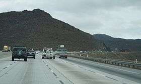
Escondido Summit
Escondido Summit, elevation 3,258 ft (993 m), is a mountain pass in northern Los Angeles County, California.
| Escondido Summit | |
|---|---|
 Northbound view from CA 14. | |
| Elevation | 3,258 ft (993 m)[1] |
| Traversed by | |
| Location | Los Angeles County, California, U.S. |
| Range | Sierra Pelona Mountains |
| Coordinates | 34°30′09″N 118°15′18″W |
| Topo map | USGS Palmdale |
It is located at the highest point along California Highway 14, which crests in the foothills of the Sierra Pelona Mountains just 3 mi (4.8 km) northwest of Acton, California.
Nearby Formations
- Soledad Pass - a second, lower mountain pass located at the highest point within Soledad Canyon.
- Soledad Canyon
- Vazquez Rocks
gollark: I mean, that would imply that your consciousness was particularly tied to those exact atoms, which would be... odd, I don't know.
gollark: *Would* you notice? That seems to assume some things.
gollark: How?!
gollark: What if 50% in one Planck time and 50% in the next one?
gollark: Is there such a thing as "different ones" if they have the same configuration though?
This article is issued from Wikipedia. The text is licensed under Creative Commons - Attribution - Sharealike. Additional terms may apply for the media files.