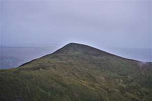
Erie Hill
Erie Hill is a hill in the Moffat Hills range, part of the Southern Uplands of Scotland. A relatively compact summit in comparison to the other hills in the range, it is commonly climbed as part of a round starting from Talla Linnfoots to the north. [1] Its name may derive from the northern Middle English 'ery', later in Scots as 'eerie' (affected by fear or dread). [2]
| Erie Hill | |
|---|---|
 | |
| Highest point | |
| Elevation | 690 m (2,260 ft) [1] |
| Prominence | 92 m (302 ft) [1] |
| Listing | Tu,Sim,D,sHu,GT,DN[1] |
| Geography | |
| Location | Scottish Borders, Scotland |
| Parent range | Moffat Hills, Southern Uplands |
| OS grid | NT 12411 18736 |
| Topo map | OS Landranger 78 |
Subsidiary SMC Summits
| Summit | Height (m) | Listing [3] |
|---|---|---|
| Laird's Cleuch Rig | 684 | Tu,Sim,DT,GT,DN[4] |
| Garelet Hill | 681 | DT,sSim[5] |
gollark: **HASKELL**THE INSANITY COMES
gollark: Can you stick an `IS TRASH` beside it?
gollark: I have a claim beside the Haskell one.
gollark: Well, maybe it shouldn't have two rshifts!
gollark: Bytecode can theoretically be loaded faster than textual code.
References
- "Erie Hill". Hill-bagging.co.uk. Retrieved 2020-04-23.
- https://dsl.ac.uk/entry/dost/ery
- Chris Crocker. "Database of British and Irish Hills: user guide". Hills-database.co.uk. Retrieved 2020-04-23.
- "Laird's Cleuch Rig [Lairds Cleuch Rig]". Hill-bagging.co.uk. Retrieved 2020-04-23.
- "Garelet Hill". Hill-bagging.co.uk. Retrieved 2020-04-23.
This article is issued from Wikipedia. The text is licensed under Creative Commons - Attribution - Sharealike. Additional terms may apply for the media files.