Ennerdale and Kinniside
Ennerdale and Kinniside is a civil parish in Copeland, Cumbria, England. At the 2011 census it had a population of 220.[1]
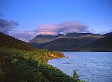
Ennerdale Water
The parish has an area of 8,763 hectares (33.83 sq mi).[1]
The village of Ennerdale Bridge is in the west of the parish; much of the parish forms Ennerdale valley, holding Ennerdale Water, the most westerly of the lakes of the Lake District.
The Anglican parish church of St Mary, Ennerdale is in Ennerdale Bridge village.[2]
Ennerdale and Kinniside C of E Primary School is in Ennerdale Bridge village.[3]
There is a parish council, the lowest tier of local government.[4][5]
Listed buildings
As of 2017 there are four listed buildings in the parish, all at grade II.
gollark: Is holiness preserved through evaporation/condensation?
gollark: We're also working on a project to replace iron mines with transubstantiation of wine and iron extraction from hemoglobin.
gollark: It's more of a metaphor.
gollark: Our nanobots can extract specifically the holy water. It's generally more convenient.
gollark: We can do that and unbaptize you too.
References
- UK Census (2011). "Local Area Report – Ennerdale and Kinniside Parish (1170219628)". Nomis. Office for National Statistics. Retrieved 23 September 2017.
- "St Mary, Ennerdale". A Church Near You. Church of England. Retrieved 23 September 2017.
- "Welcome to our School". Ennerdale and Kinniside C of E Primary School.
- "Welcome". Ennerdale and Kinniside Parish Council. Retrieved 23 September 2017.
- "Ennerdale and Kinniside Parish Council". Cumbria County Council. Retrieved 23 September 2017.
This article is issued from Wikipedia. The text is licensed under Creative Commons - Attribution - Sharealike. Additional terms may apply for the media files.