Emmonak Airport
Emmonak Airport (IATA: EMK, ICAO: PAEM, FAA LID: ENM) is a state-owned public-use airport located in Emmonak,[1] a city in the Kusilvak Census Area of the U.S. state of Alaska.
Emmonak Airport | |||||||||||
|---|---|---|---|---|---|---|---|---|---|---|---|
 | |||||||||||
| Summary | |||||||||||
| Airport type | Public | ||||||||||
| Owner | State of Alaska DOT&PF - Northern Region | ||||||||||
| Serves | Emmonak, Alaska | ||||||||||
| Elevation AMSL | 13 ft / 4 m | ||||||||||
| Coordinates | 62°47′10″N 164°29′27″W | ||||||||||
| Runways | |||||||||||
| |||||||||||
| Statistics (2016) | |||||||||||
| |||||||||||
Although most U.S. airports use the same three-letter location identifier for the FAA and IATA, this airport is assigned ENM by the FAA[1] and EMK by the IATA.[3] The airport's ICAO identifier is PAEM.[4]
Facilities
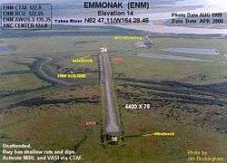
Emmonak Airport has one runway designated 16/34 with a gravel surface measuring 4,601 by 100 feet (1,402 x 30 m).[1]
Airline and destinations
| Airlines | Destinations |
|---|---|
| Grant Aviation | Alakanuk, Bethel, Kotlik, Nunma Iqua[5] |
Prior to its bankruptcy and cessation of all operations, Ravn Alaska served the airport from multiple locations.
Statistics
| Carrier | Passengers (arriving and departing) |
|---|---|
| Grant | 11,540(78.28%) |
| Hageland | 3,080(20.90%) |
| Era | 120(0.81%) |
| Rank | City | Airport | Passengers |
|---|---|---|---|
| 1 | Bethel Airport | 3,770 | |
| 2 | St. Marys Airport | 1,090 | |
| 3 | Kotlik Airport | 1,040 | |
| 4 | Alakanuk Airport | 720 | |
| 5 | Sheldon Point Airport | 480 | |
| 6 | Ted Stevens Anchorage International Airport | 110 |
gollark: The desktop app security model is actually really bad.
gollark: The browser could, but presumably won't track that or pass it onto pages.
gollark: Yep!
gollark: Anyway, discord in browser: I get to piggyback off the RAM use and stuff of my browser instance instead of feeding a bloated electron app. No update issues. Probably less telemetry.
gollark: Um, it was a joke. I'm not actually a HTML parser.
References
- FAA Airport Master Record for ENM (Form 5010 PDF), effective 2009-07-02.
- "Emmonak, AK: Emmonak (EMK)". Bureau of Transportation Statistics (BTS), Research and Innovative Technology Administration (RITA), U.S. Department of Transportation. December 2016. Retrieved May 9, 2017.
- Great Circle Mapper: EMK / PAEM - Emmonak, Alaska
- "Alaskan ICAO Identifiers". Federal Aviation Administration. Archived from the original on 2009-07-28. Retrieved 2009-08-07.
- "Grant Aviation Schedule". (retrieved May 9, 2017)
External links
- FAA Alaska airport diagram (GIF)
- FAA Terminal Procedures for ENM, effective July 16, 2020
- Resources for this airport:
- FAA airport information for ENM
- AirNav airport information for PAEM
- ASN accident history for EMK
- FlightAware airport information and live flight tracker
- NOAA/NWS latest weather observations for PAEM
- SkyVector aeronautical chart for ENM
This article is issued from Wikipedia. The text is licensed under Creative Commons - Attribution - Sharealike. Additional terms may apply for the media files.