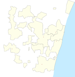
Embalam
Embalam is a panchayat village[1] in Nettapakkam Commune in the Union Territory of Puducherry, India.
Embalam | |
|---|---|
Village | |
 Embalam Location in Puducherry, India  Embalam Embalam (India) | |
| Coordinates: 11.871215°N 79.713514°E | |
| Country | |
| State | Puducherry |
| District | Pondicherry |
| Taluk | Bahour |
| Commune | Nettapakkam |
| Languages | |
| • Official | French, Tamil, English |
| Time zone | UTC+5:30 (IST) |
| PIN | 605 106 |
| Telephone code | 0413 |
| Vehicle registration | PY-01 |
| Sex ratio | 50% ♂/♀ |
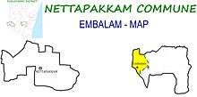
Embalam, Nettapakkam Commune
Geography
Embalam is bordered by Nallathur village (Tamil nadu) in the west, Sathamangalam in the north, Sembiapalayam in the east and Manaveli village (Tamil nadu) in the south and south-west.
Transport
Embalam is located at 18 km. from Pondicherry. Embalam can be reached directly by any bus running between Pondicherry and Maducarai via. Embalam.
Road Network
Embalam is connected to Pondicherry by Thavalakuppam-Embalam (RC-20) State Highway. Also Mangalam-Maducarai State Highway (RC-19) passes through Embalam
Politics
Embalam is a part of Embalam (Union Territory Assembly constituency) which comes under Puducherry (Lok Sabha constituency)
Gallery
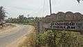 Way to Embalam
 Embalam Village Panchayat
gollark: Yes.
gollark: Stop using the passive voice!
gollark: Backup Esobot enabled.
gollark: !help
gollark: Make me admin so I can stop LyricLy being evil.
References
- "Archived copy" (PDF). Archived from the original (PDF) on 27 September 2013. Retrieved 5 March 2013.CS1 maint: archived copy as title (link)
This article is issued from Wikipedia. The text is licensed under Creative Commons - Attribution - Sharealike. Additional terms may apply for the media files.