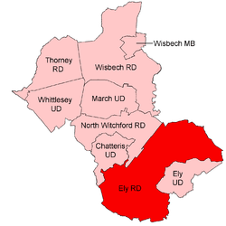
Ely Rural District
Ely was a rural district in England from 1894 to 1974.[1] It was named after Ely, and surrounded it to the west and north. The district was created in 1894 under the Local Government Act 1894 from the Ely rural sanitary district. It formed part of the administrative county of the Isle of Ely from 1894 to 1965, when this was merged into Cambridgeshire and Isle of Ely.

The district comprised the parishes of Coveney, Downham, Grunty Fen, Haddenham, Littleport, Mepal, Redmere, Stretham, Sutton, Thetford, Wentworth, Wilburton, Witcham and Witchford.
In 1974 it was abolished, and its area made part of the new East Cambridgeshire district of Cambridgeshire.
Redmere Rural District
Redmere Rural District[2] was (at least nominally) a short-lived entity created in 1894 containing the only parish, Redmere, which had been in Ely RSD but lay in Norfolk rather than the Isle of Ely. Its population at the time was about 40.[3] In 1895 the parish was transferred to the Isle, and Redmere RD was absorbed by Ely RD. There does not appear to be any evidence that it ever actually functioned.
Statistics
| Year | Area (ha) [4] |
Population [5] |
Density (pop/ha) |
|---|---|---|---|
| 1911 | 25,900 | 12,916 | 0.50 |
| 1921 | 12,883 | 0.50 | |
| 1931 | 13,532 | 0.52 | |
| 1951 | 26,743 | 14,717 | 0.55 |
| 1961 | 14,442 | 0.54 |
References
- "Ely RD through time: Census tables with data for the Local Government District". A Vision of Britain through Time. GB Historical GIS / University of Portsmouth. Retrieved 26 June 2017.
- "Redmere ExP/CP through time: Census tables with data for the Local Government District". A Vision of Britain through Time. GB Historical GIS / University of Portsmouth. Retrieved 26 June 2017.
- "Redmere ExP/CP through time: Population Statistics: Males and Females". A Vision of Britain through Time. GB Historical GIS / University of Portsmouth. Retrieved 25 June 2017.
- "Ely RD through time: Population Statistics: Area (acres)". A Vision of Britain through Time. GB Historical GIS / University of Portsmouth. Retrieved 26 June 2017.
- "Ely RD through time: Population Statistics: Total Population". A Vision of Britain through Time. GB Historical GIS / University of Portsmouth. Retrieved 26 June 2017.