Elle (river)
The Elle is a 31.8 km long river in Normandy, a right bank affluent of the Vire.
| Elle | |
|---|---|
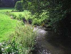 river at Saint-Jean-de-Savigny | |
| Physical characteristics | |
| Source | |
| • location | Les Navignes, Rouxeville |
| • coordinates | 49.1045°N 0.9404°W |
| • elevation | 165 m (541 ft) |
| Mouth | |
• location | Vire, Neuilly-la-Forêt |
• coordinates | 49.2764°N 1.1223°W |
• elevation | 1 m (3.3 ft) |
| Length | 31.8 km (19.8 mi) |
| Basin size | 129 km2 (50 sq mi) |
| Discharge | |
| • average | 0.628 m3/s (22.2 cu ft/s) (Saint-Jean-de-Savigny) |
| Basin features | |
| Progression | Vire→ English Channel |
| Tributaries | |
| • right | Rieu |
| Source | Géoportail, Sandre, base Hydro de eaufrance.fr |
Topography
It crops north of Rouxeville. It joins la Vire (river) at Neuilly-la-Forêt in the Marais du Cotentin et du Bessin between Bessin and Pays saint-lois.
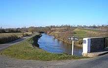
Elle at Neuilly-la-Forêt
Tributaries
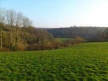
Vallée de l'Elle à Cerisy-la-Forêt
L'Elle has several affluents ~ among them:
- one main affluent : the Rieu (12.2 km) which joins right bank at Lison. The Rieu collects the waters of the north-eastern part of the basin, located between those of l'Aure (north) and the Vire (east) and a few of its tributaries to the south and the east.
- le ruisseau de Branche (6.7 km) joins the Elle left bank at Saint-Jean-de-Savigny.
Communes
- Rouxeville (spring source at 200 m),
- Saint-Germain-d'Elle,
- Bérigny, où se joignent des ramifications secondaires venant de Saint-Jean-des-Baisants et Notre-Dame-d'Elle,
- Saint-Georges-d'Elle (en limite est),
- Montfiquet (en limite ouest),
- Cerisy-la-Forêt,
- Sainte-Marguerite-d'Elle (en limite sud),
- Saint-Jean-de-Savigny (en limite nord),
- Saint-Clair-sur-l'Elle (en limite nord),
- Moon-sur-Elle,
- Airel,
- Lison (en limite ouest),
- Neuilly-la-Forêt (confluent avec la Vire),
gollark: All the cool bots are using GPT-3.
gollark: If you make a web API I can have it interface with it.
gollark: Could I add this to AutoBotRobot?
gollark: øĸæ←
gollark: It's a future 3D version which is also Minecraft.
References
This article is issued from Wikipedia. The text is licensed under Creative Commons - Attribution - Sharealike. Additional terms may apply for the media files.