Elder Parish, New South Wales
Located at 30°43′10″S 143°06′00″E, Elder, New South Wales is a remote rural locality and civil parish of Yungnulgra County in far North West New South Wales.[1][2]
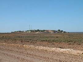
View of the parish with Whitcliffs in the distance
Geography
The Parish an arid landscape. The nearest town is Whitecliffs 2 km to the south.
Climate
The parish has extremely hot summers and mild winters. Summers would usually exceed 36°C. Winters are usually around 17 °C. The annual average rainfall is 249.7 millimetres (9.8 in) which would make it a semi-arid climate except that its high evapotranspiration, or its aridity, makes it a desert climate. The parish has a Köppen climate classification of BWh (Hot desert),.[3] is almost unpopulated, with less than two inhabitants per square kilometer.[4]
| Climate data for White Cliffs Post Office (1901–2012) | |||||||||||||
|---|---|---|---|---|---|---|---|---|---|---|---|---|---|
| Month | Jan | Feb | Mar | Apr | May | Jun | Jul | Aug | Sep | Oct | Nov | Dec | Year |
| Record high °C (°F) | 48.6 (119.5) |
46.9 (116.4) |
44.1 (111.4) |
37.9 (100.2) |
31.9 (89.4) |
28.0 (82.4) |
28.8 (83.8) |
33.0 (91.4) |
39.5 (103.1) |
41.7 (107.1) |
45.0 (113.0) |
45.8 (114.4) |
48.6 (119.5) |
| Average high °C (°F) | 35.8 (96.4) |
34.9 (94.8) |
31.6 (88.9) |
26.4 (79.5) |
21.4 (70.5) |
17.6 (63.7) |
17.2 (63.0) |
19.7 (67.5) |
23.9 (75.0) |
27.9 (82.2) |
31.5 (88.7) |
34.4 (93.9) |
26.9 (80.4) |
| Average low °C (°F) | 20.9 (69.6) |
20.4 (68.7) |
17.2 (63.0) |
12.4 (54.3) |
8.2 (46.8) |
5.3 (41.5) |
4.1 (39.4) |
5.6 (42.1) |
9.0 (48.2) |
12.9 (55.2) |
16.4 (61.5) |
19.2 (66.6) |
12.6 (54.7) |
| Record low °C (°F) | 12.1 (53.8) |
8.8 (47.8) |
7.2 (45.0) |
2.6 (36.7) |
−0.5 (31.1) |
−2.3 (27.9) |
−3.3 (26.1) |
−1.7 (28.9) |
0.2 (32.4) |
2.0 (35.6) |
3.4 (38.1) |
6.8 (44.2) |
−3.3 (26.1) |
| Average precipitation mm (inches) | 27.7 (1.09) |
27.1 (1.07) |
23.8 (0.94) |
15.4 (0.61) |
20.8 (0.82) |
19.0 (0.75) |
18.2 (0.72) |
15.4 (0.61) |
15.0 (0.59) |
23.2 (0.91) |
19.2 (0.76) |
25.1 (0.99) |
249.7 (9.83) |
| Average precipitation days | 3.0 | 2.8 | 2.5 | 2.2 | 3.4 | 3.7 | 3.8 | 3.4 | 3.0 | 3.6 | 3.1 | 3.0 | 37.5 |
| Source: [5] | |||||||||||||
gollark: Sad!
gollark: Basically, it lets you Securely get a SHell session on another thing over the internet.
gollark: I manage the osmarks.tk apeirocluster via secure SSH shell.
gollark: It's useful!
gollark: You should!
References
- "Yungnulgra". Geographical Names Register (GNR) of NSW. Geographical Names Board of New South Wales. Retrieved 30 July 2013.

- Historic map of Yungnulgra County.
- Peel, M. C.; Finlayson, B. L.; McMahon, T. A. (2007). "Updated world map of the Köppen–Geiger climate classification". Hydrol. Earth Syst. Sci. 11: 1633–1644. doi:10.5194/hess-11-1633-2007. ISSN 1027-5606. (direct: Final Revised Paper)
- NASA Earth Observations: Population Density”. NASA/SEDAC..
- "Climate statistics for Australian locations". bom.gov.au. Retrieved 18 March 2018.
This article is issued from Wikipedia. The text is licensed under Creative Commons - Attribution - Sharealike. Additional terms may apply for the media files.