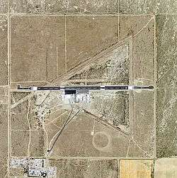
El Mirage Field
El Mirage Field is a private airport located 3 miles west of El Mirage, California. It is leased by General Atomics of San Diego. Its primary use is the development and testing of Unmanned Aerial Vehicles (UAV) for the United States Military and US Government.
El Mirage Field Adelanto Airport Mirage Auxiliary Airfield | |||||||||||||||||||
|---|---|---|---|---|---|---|---|---|---|---|---|---|---|---|---|---|---|---|---|
 2006 USGS airphoto | |||||||||||||||||||
| Summary | |||||||||||||||||||
| Serves | El Mirage, California | ||||||||||||||||||
| Coordinates | 34°37′24″N 117°35′59″W | ||||||||||||||||||
| Map | |||||||||||||||||||
 99CL Location of El Mirage Field | |||||||||||||||||||
| Runways | |||||||||||||||||||
| |||||||||||||||||||
El Mirage Field, has a sister site located at Grey Butte Field Airport.
History
During World War II, the airport was designated as Mirage Auxiliary Airfield (No 3), and was an auxiliary training airfield for Victorville Army Airfield, California.
The wartime runways are abandoned and not used by General Atomics for their UAV testing.
gollark: *Who* can't consent though?
gollark: I mean, lots of things are *allegedly* for this.
gollark: Ominous™ ones.
gollark: Er. Bye then? Not that Danny can enforce stuff now.
gollark: I *can* actually delete things, but this is the extent of my moderate powers.
References
![]()
- Abandoned & Little-Known Airfields: California - Southern Palmdale area
External links
This article is issued from Wikipedia. The text is licensed under Creative Commons - Attribution - Sharealike. Additional terms may apply for the media files.
