Eiseb
Eiseb, also Eiseb Block, is a settlement in the Omaheke Region of Namibia. It is named after the Eiseb River, an ephemeral river (omuramba) in the Kalahari desert. Eiseb is situated on the District road D1635 c. 350 kilometres (220 mi) northeast of Talismanus and belongs to the Otjombinde electoral constituency.[2][3]
Eiseb | |
|---|---|
Village | |
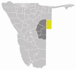
 Otjombinde Constituency (yellow) in the Omaheke Region (dark grey) | |
| Country | |
| Region | Omaheke Region |
| Constituency | Otjombinde Constituency |
| Population (2011)[1] | |
| • Total | 2,102 |
| Time zone | UTC+2 (SAST) |
The settlement has been established in 1992 as a place where returning Ovambanderu and Ovaherero refugees from Botswana could settle. From 1994 onwards, Ovambanderu and Ovaherero from other reserved areas, such as Epukiro, Otjinene and Otjombinde moved in and make up the majority of the inhabitants today, making a living from subsistence farming.[4]
Eiseb-Epukiro River Basin
The area between Eiseb and Epukiro is one of eleven water basins in Namibia. It has a total surface area of 10,665 square kilometres (4,118 sq mi) and borders Botswana in the east, reaches southwards until Gobabis, and covers parts of the Omaheke and Otjozondjupa Regions. The total annual water yield of the basin is 20 million cubic metres (710×106 cu ft), mainly ground water.[5]
References
- "Table 4.2.2 Urban population by Census years (2001 and 2011)" (PDF). Namibia 2011 - Population and Housing Census Main Report. Namibia Statistics Agency. p. 39. Archived from the original (PDF) on 2 October 2013. Retrieved 10 September 2013.
- "Nguvauva wants Eiseb Block to be declared a constituency". New Era. 17 November 2015.
- "Du Plessis-Epukiro road upgrade next financial year". The Namibian. 30 January 2018. p. 6.
- Tjatindi, Charles (30 January 2018). "Eiseb farmers want auction facilities". The Namibian. p. 16.
- "Integrated Water Resources Management" (PDF). Ministry of Agriculture, Water and Forestry. p. 4. Retrieved 30 January 2018.