Einthoven Hill
Einthoven Hill (64°14′S 62°9′W) is a hill at the south extremity of Avroleva Heights, 3 nautical miles (6 km) southwest of Mitchell Point on the east side of Brabant Island in the Palmer Archipelago, Antarctica. It was photographed by Hunting Aerosurveys Ltd in 1956–57, and mapped from these photos in 1959. It was named by the UK Antarctic Place-Names Committee for Willem Einthoven, the Dutch inventor of the electrocardiograph.[1]
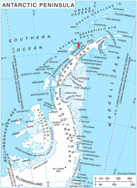
Location of Brabant Island in the Antarctic Peninsula region.
Maps
- Antarctic Digital Database (ADD). Scale 1:250000 topographic map of Antarctica. Scientific Committee on Antarctic Research (SCAR). Since 1993, regularly upgraded and updated.
- British Antarctic Territory. Scale 1:200000 topographic map. DOS 610 Series, Sheet W 64 62. Directorate of Overseas Surveys, Tolworth, UK, 1980.
- Brabant Island to Argentine Islands. Scale 1:250000 topographic map. British Antarctic Survey, 2008.
gollark: I think that's *roughly* what it does anyway.
gollark: Maybe I should timestamp them.
gollark: It might actually be worth implementing a better signing/trust system than "everything is signed with the master key".
gollark: I could probably make the PX signing program stick `return` on the end, but then I would have to revoke existing programs and I didn't add a mechanism for that.
gollark: You know, most of the sandbox exploits have just focused on finding the many logic errors/weird environment issues, not exploiting crypto. This is an interesting change, at least.
References
- "Einthoven Hill". Geographic Names Information System. United States Geological Survey. Retrieved 2012-02-27.

Brabant Island seen from northeast, with Anvers Island (on the right) and Antarctic Peninsula in the background.
![]()
This article is issued from Wikipedia. The text is licensed under Creative Commons - Attribution - Sharealike. Additional terms may apply for the media files.