Ebersroda
Ebersroda is a village and a former municipality in the Burgenlandkreis district, in Saxony-Anhalt, Germany. Since 1 July 2009, it is part of the municipality Gleina.
Ebersroda | |
|---|---|
Ortsteil of Gleina | |
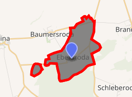
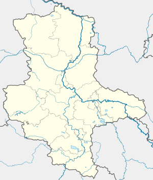
Location of Ebersroda 
| |
 Ebersroda  Ebersroda | |
| Coordinates: 51°15′0″N 11°46′0″E | |
| Country | Germany |
| State | Saxony-Anhalt |
| District | Burgenlandkreis |
| Town | Gleina |
| Area | |
| • Total | 4.27 km2 (1.65 sq mi) |
| Elevation | 210 m (690 ft) |
| Population (2006-12-31) | |
| • Total | 183 |
| • Density | 43/km2 (110/sq mi) |
| Time zone | CET/CEST (UTC+1/+2) |
| Postal codes | 06632 |
| Dialling codes | 034632 |
| Vehicle registration | BLK |
| Website | www.vgem-unstruttal.de |
The village Ebersroda has been proposed by Germany for inscription in the List of World Heritage. The World Heritage nomination Naumburg Cathedral and the High Medieval Cultural Landscape of the Rivers Saale and Unstrut is representative for the processes that shaped the continent during the High Middle Ages between 1000 and 1300: Christianization, the so-called “Landesausbau” and the dynamics of cultural exchange and transfer characteristic for this very period.[1]
World Heritage Nomination

The village Ebersroda is one of the eleven components of the cultural landscape Naumburg Cathedral and the High Medieval Cultural Landscape of the Rivers Saale and Unstrut that has been proposed by the Federal Republic of Germany for inscription in the List of World Heritage. [note 1] The World Heritage nomination is representative for the pervasive processes that shaped the continent during the High Middle Ages between 1000 and 1300: Christianization, the so-called “Landesausbau” and the dynamics of cultural exchange and transfer characteristic for this very period.[2]
History
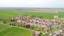
This component part encompasses the village of Ebersroda located north of the Unstrut River on the adjoining plateau of Querfurt-Gleina. As the neighboring village Schleberoda, Ebersroda was founded as a result of intensive land development by clearance in the High Middle Ages such as other villages with “root” (Roda) in the name [3] (e.g. Albersroda, Baumersorda, Schnellroda, Ebersroda and Schleberoda).[1] Ebersroda is a characteristic village built around a village green only accessible from one side. The oval-shaped green at the centre of the village community features a continuity of use, which has survived over the centuries, with a village pond, two well houses, a bake house and a brewery.[4]
Today

The farmsteads with forward-facing gables and with partly elaborate gates or portals have repeatedly been renovated on a persistent ground plan dating from the High Middle Ages; their building fabric today dates from the 17th to 20th century. The belt of barns terminating the farmsteads has been completely preserved. Around the gardens and meadows adjoining each barn, a path that can be accessed from each farmstead still marks the original village boundary today. [5] The churchyard is located on the north-eastern edge of the village and is surrounded by a lane. From the church that existed in the High Middle Ages, a high choir tower with a wall bond of opus spicatum and coupled abat sons remains. A Baroque hall church was adjoined to this tower on the eastern side in the 18th century. [6] [7]
See also
- World Heritage Convention
- World Heritage site
- World Heritage Committee
- High Middle Ages
- Cultural Landscape
References
- Bartlett, Robert (1994). The Making of Europe: Conquest, Colonization and Cultural Change 950-1350. Penguin.
- UNESCO (2017): WHC/17/41.COM/INF.8B1.Nominations to the World Heritage List (Krakow, 2017). UNESCO press. p. 54. Retrieved 5 May 2017.
- Eichler, Ernst (1994). Slawische Ortsnamen zwischen Saale und Neiße [Slav names of villages between Saale and Neiße.] (in German). Bautzen. pp. 1–4.
- Walter, Hans (1971). Namenkundliche Beiträge zur Siedlungsgeschichte des Saale- und Mittelelbegebietes bis zum Ende des 9. Jahrhunderts (Deutsch-Slawische Forschungen zur Namenkunde und Siedlungsgeschichte 26) [The history of names in the settlement in the area of the Saale and the Elbeuntil the end of the 9th century (German-Slav research on the history of names and settlements 26).] (in German). Berlin.
- Gringmuth-Dallmer, Eike (2006). Die hochmittelalterliche Ostsiedlung in vergleichender Sicht In: Siedlungsforschung 24 [The high-medieval Eastern settlement processes from a comparative point of view. In: Settlement history 24.] (in German). pp. 99–122.
- Naumann, Louis (1993). Zur Geschichte der sogenannten "Kreisdörfer" im Naumburger Kreise. Eine agrarhistorische Studie In: Thüringisch-sächsische Zeitschrift für Geschichte und Kunst. Band 3 [On the history of the so-called cicle-villages around Naumburg. In: Thuringia and Saxon journal on history and arts.] (in German). Saxony-Anhalt. pp. 169–208.
- Hardt, Matthias (2000). Linien und Säume, Zonen und Räume an der Ostgrenze des Reiches im frühen und hohen Mittelalter In: Grenze und Differenz im frühen Mittelalter (Österreichische Akademischer Wissenschaften, philosophisch-historische Klasse, Denkschriften 287, Forschungen zur Geschichte des Mittelalters 1) [Lines, barriers, zones and areas at the frontier of the empire of the Early and High Middle Ages. In: Austrian Academic Sciences,research on the history of the Middle Ages .] (in German). Wien. pp. 39–56.
Notes
- The Förderverein Welterbe an Saale und Unstrut e.V. is the coordinating body for this World Heritage nomination: http://www.naumburg-cathedral.de.
External links
Category:Cultural heritage Category:Cultural studies Category:High Middle Ages Category:Landscape Category:Saxony-Anhalt