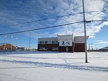
Eastmain
Eastmain (Quebec French pronunciation: [iːstmẽɪ̯̃]; Cree: ᐄᔅᒣᐃᓐ/Îsmein) is a Cree community located on east coast of James Bay at the mouth of the Eastmain River, Quebec, Canada. It is a small coastal Cree village with a population of 866 people in the 2016 Canadian Census up from 767 people at the 2011 Canadian Census.[2] Its alternate Cree name is ᐙᐸᓅᑖᐤ/Wâpanûtâw, meaning Lands east of James Bay.
Eastmain ᐄᔅᒣᐃᓐ (Îsmein) | |
|---|---|
Terre réservée crie (Cree reserved land) | |
 Eastmain Eastmain  Eastmain Eastmain (Canada) | |
| Coordinates: 52°15′N 78°30′W[1] | |
| Country | Canada |
| Province | Quebec |
| Region | Nord-du-Québec |
| Territory | Eeyou Istchee |
| Area | |
| • Total | 160.43 km2 (61.94 sq mi) |
| • Land | 158.41 km2 (61.16 sq mi) |
| Population | |
| • Total | 866[2] |
| Website | Eastmain.ca |
Like the other coastal villages on Hudson and James Bay, Eastmain was settled around a Hudson's Bay Company trading post, which was originally called East Main House. Some Cree settled there for ease in trading.
Eastmain is accessible by air (Eastmain River Airport) and by car over a gravel road linking it to the James Bay Road.
The Eastmain community was greatly affected by the James Bay Project, which in 1980 diverted 90% of the Eastmain River to the La Grande River.
Education

The Cree School Board operates the Wabannutao Eeyou School (Cree: ᐧᐋᐸᓅᑖᐤ ᐄᔨᔫ ᒋᔅᑯᑕᒫᒉᐅᑲᒥᒄ).[4]
See also
References
- Reference number 20121 of the Commission de toponymie du Québec (in French)
- "(Code 2499810) Census Profile". 2016 census. Statistics Canada. 2017.
- Geographic code 99810 in the official Répertoire des municipalités (in French)
- "Wabannutao Eeyou School Archived 2017-09-23 at the Wayback Machine." Cree School Board. Retrieved on September 23, 2017.