Dry Creek (Mokelumne River tributary)
Dry Creek is a 47.1-mile-long (75.8 km)[1] stream in northern California which runs from the Sierra Nevada to the Mokelumne River west of Galt.
| Dry Creek | |
|---|---|
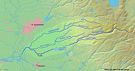 Map of the Mokelumne River watershed | |
| Location | |
| Country | United States |
| State | California |
| Region | Amador County, Sacramento County, San Joaquin County |
| Physical characteristics | |
| Source | |
| • coordinates | 38°28′13″N 120°48′40″W |
| Mouth | Mokelumne River |
• location | California, United States |
• coordinates | 38°13′55″N 121°24′42″W |
• elevation | 13 ft (4.0 m) |
Tributaries
- North Fork Dry Creek
- South Fork Dry Creek
- Sutter Creek
- Jackson Creek
gollark: And how do I make the initial `request` nonblocking?
gollark: `http_response` only appears in the code in what looks like one comment.
gollark: It doesn't seem to be.
gollark: There seems to be an `internet_ready` signal, I'll check if that's relevant to HTTP.
gollark: I have some code doing this```lualocal function fetch(url, data) local res, err = net.request(url, json.encode(data), { ["Content-Type"] = "application/json" }) if not res then error(url .. " error: " .. err) end local out = {} while true do local chunk, err = res.read() if err then error(url .. " error: " .. err) end if chunk then table.insert(out, chunk) else return table.concat(out) end endend```but it never appears to `computer.pullSignal` at all, so my accursed bare-metal multithreading thing™ doesn't work.
See also
| Wikimedia Commons has media related to Dry Creek (Mokelumne River). |
References
- U.S. Geological Survey. National Hydrography Dataset high-resolution flowline data. The National Map Archived 2012-04-05 at WebCite, accessed March 11, 2011
This article is issued from Wikipedia. The text is licensed under Creative Commons - Attribution - Sharealike. Additional terms may apply for the media files.