Drieňok
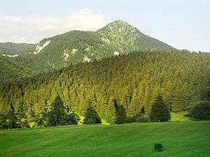
Drieňok is a mountain in the Greater Fatra Range of Slovakia measuring 1,268 m (4,160 ft). The typical pyramidal shape of the mountain, which lies on the edge of the range, steeply rises over the Turiec valley and is easily recognizable from any direction. Under the summit there is an emblematic dead and dry tree.
| Drieňok | |
|---|---|
 | |
| Highest point | |
| Elevation | 1,268 m (4,160 ft) |
| Coordinates | 48°53′25″N 18°57′42″E |
| Geography | |
 Drieňok Location in Slovakia | |
| Location | Turčianske Teplice, Žilina, Slovakia |
| Parent range | Greater Fatra |
| Geology | |
| Mountain type | limestone and dolomite |
Gallery
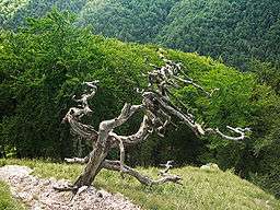
The emblematic dead tree under the summit
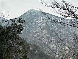
Winter view at Drieňok
gollark: (Also, most people who die from it are still old enough that they're unlikely to have more children.)
gollark: That wouldn't actually work. People not getting a vaccine affects people other than them quite a lot.
gollark: I doubt it actually makes it problematically contagious though.
gollark: https://blogs.sciencemag.org/pipeline/archives/2021/04/28/brazil-rejects-the-gamaleya-vaccine
gollark: Apparently there are some quality control issues with the Russian Sputnik V vaccine and some of it actually is replication-capable.
References
- Brandos, Otakar (2004). Veľká Fatra, Šípska Fatra. Ostrava: SKY. ISBN 80-86774-02-3.
- VKÚ Harmanec (2003). Veľká Fatra. Edícia turistických máp 1:50000. Harmanec: VKÚ. ISBN 80-8042-044-0.
This article is issued from Wikipedia. The text is licensed under Creative Commons - Attribution - Sharealike. Additional terms may apply for the media files.