Dragons Teeth (Antarctica)
Dragons Teeth (63°15′S 58°39′W) are a small group of rocks rising to c. 100 m off Kanarata Point, the northeast extremity of Astrolabe Island, off Trinity Peninsula in Antarctica. They were photographed from the air and surveyed from the ground by FIDASE, 1955–57. The name, applied by UK-APC, is descriptive of these black tooth-shaped rocks.
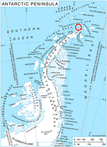
Location of Astrolabe Island in the Antarctic Peninsula region.
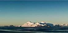
Astrolabe Island from northwest, with the Dragons Teeth on the left, and Drumohar Peak and Rogach Peak dominating the island.
Maps
- Trinity Peninsula. Scale 1:250000 topographic map No. 5697. Institut für Angewandte Geodäsie and British Antarctic Survey, 1996.
- Antarctic Digital Database (ADD). Scale 1:250000 topographic map of Antarctica. Scientific Committee on Antarctic Research (SCAR). Since 1993, regularly upgraded and updated.
gollark: Sometimes I feel like people talk about themselves being trans vaguely excessively and it comes across that way, although there's probably selection bias there.
gollark: I mostly enjoy some poorly defined subset of metalcore.
gollark: <@534472180273119253> I do not.
gollark: Why not "every homosexual being"?
gollark: The orbital gender spy satellites would alert all your social contacts if you violate gender roles.
References
- Dragons Teeth. SCAR Composite Antarctic Gazetteer.
![]()
![]()
This article is issued from Wikipedia. The text is licensed under Creative Commons - Attribution - Sharealike. Additional terms may apply for the media files.