Drüber
Drüber is a southern suburb of the city of Einbeck, district Northeim. It has 494 inhabitants, of which 259 are male, and 235 female.[1]
Drüber | |
|---|---|
Suburb of Einbeck | |
Location of Drüber 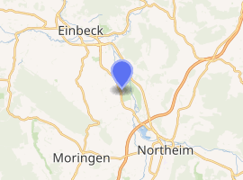
| |
 Drüber 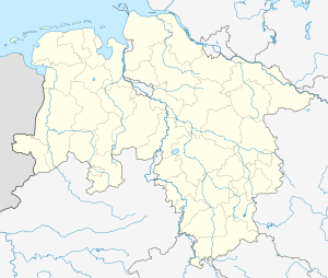 Drüber | |
| Coordinates: 51°45′44″N 09°55′51″E | |
| Country | Germany |
| State | Lower Saxony |
| District | Northeim |
| Town | Einbeck |
| Elevation | 116 m (381 ft) |
| Population (2010-10-00) | |
| • Total | 494 |
| Time zone | CET/CEST (UTC+1/+2) |
| Postal codes | 37574 |
| Dialling codes | 05561 |
| Vehicle registration | NOM, EIN |
Geography
Drüber lies in southern Lower Saxony between the Harz and Solling Mountains. It is located 1 km west of the river Leine, at the western edge of the Leine Graben[2] in the Leine Uplands. The village is immediately west of the nature reserve that is located in the flood retention basin Salzderhelden. It is situated roughly midway between the cities Einbeck and Northeim. The size of the village is 880 acres. Its neighboring villages are Sülbeck to the north, in the east Hohnstedt on the far side of the river Leine. South of Drüber is Stöckheim and Buensen is located to the west.
History
Written records about Drüber start relatively late. In a deed from 1238 given by Otto I, Duke of Brunswick-Lüneburg a certain Ludolf von Drübere is mentioned.[3] Due to its name it is thought that Drüber might be one of the oldest villages in the area.[3] In 1886 a cooperative dairy was opened in Drüber by farmers from the villages around it. In 1970 that dairy was closed. On 1 December 1 1962 a central school for the villages Buensen, Drüber, Hollenstedt, Immensen, and Sülbeck started operation. Before that time only single classroom schools were used in these villages. The school was enlarged over time and is still operating under the name "Leinetalschulen" (Leine-Valley-Schools).[4]
On 1. March 1974 the village was incorporated into the city of Einbeck.[5]
Politics
Village Council Drüber/Sülbeck
Mayor of the village is Rolf Metje (SPD). The current legislative period runs from 1 November 2011 until 31 October 2016.
There is a joint Village Council with Sülbeck. The by-election on 20 January 2013, due to the incorporation of the former city of Kreiensen into the city of Einbeck, brought the following results for the Village Council:
- SPD Six Seats
- Wählergemeinschaft Drüber-Sülbeck Three Seats
Coat of Arms of Drüber
The coat of arms shows three green trees above a canal (Salzgraben) that ran around Drüber to supply the salt works in Sülbeck with water.
References
- "Stadt Einbeck: Einwohnerstatistik Oktober 2010 (PDF; 38 kB)" (PDF). Einbeck.de. Retrieved March 22, 2011.
- Hansjörg Küster (1995). Geschichte der Landschaft in Mitteleuropa: von der Eiszeit bis zur Gegenwart. C.H. Beck. p. 26. ISBN 9783406453571. Retrieved 2013-09-08.
- Einbecker Geschichtsverein (ed.): Einbecks Dörfer - Bilder aus vergangenen Zeiten, Duderstadt 1995, p. 128 f. (in German)
- "Willkommen auf der Homepage der Leinetalschulen DrĂźber - FĂśrderschule Lernen". Leinetalschulen-drueber.de. 2011-06-16. Archived from the original on 2013-05-01. Retrieved 2013-09-08.
- Statistisches Bundesamt, ed. (1983), Historisches Gemeindeverzeichnis für die Bundesrepublik Deutschland. Namens-, Grenz- und Schlüsselnummernänderungen bei Gemeinden, Kreisen und Regierungsbezirken vom 27. 5. 1970 bis 31. 12. 1982 (in German), Stuttgart und Mainz: Kohlhammer Verlag, p. 207, ISBN 3-17-003263-1 (in German)
Literature
- Einbecker Geschichtsverein e. V. (Hrsg.): Einbecks Dörfer - Bilder aus vergangenen Zeiten. Duderstadt 1995. ISBN 3-923453-64-7 (in German)
External links
- Homepage of the City of Einbeck with information about the suburb Drüber (in German)
- Homepage of Heimatverein Leinetal e.V. with information and photos from Drüber (in German)