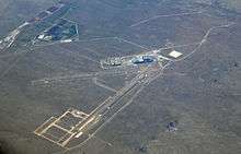
Double Eagle II Airport
Double Eagle II Airport (ICAO: KAEG, FAA LID: AEG) is a public airport located seven miles (11 km) northwest of the central business district of Albuquerque, a city in Bernalillo County, New Mexico, United States. It is owned by the City of Albuquerque.[1]
Double Eagle II Airport | |||||||||||||||
|---|---|---|---|---|---|---|---|---|---|---|---|---|---|---|---|
 | |||||||||||||||
| Summary | |||||||||||||||
| Airport type | Public | ||||||||||||||
| Owner | City of Albuquerque | ||||||||||||||
| Serves | Albuquerque, New Mexico | ||||||||||||||
| Elevation AMSL | 5,837 ft / 1,779 m | ||||||||||||||
| Coordinates | |||||||||||||||
| Map | |||||||||||||||
 AEG Location of airport in New Mexico / United States  AEG AEG (the United States) | |||||||||||||||
| Runways | |||||||||||||||
| |||||||||||||||
| Statistics (2018) | |||||||||||||||
| |||||||||||||||
Located on the far west side of the city, it is Albuquerque's second airport after Albuquerque International Sunport. Construction began in 1982, and the airport was named for the Double Eagle II balloon, the first balloon to cross the Atlantic Ocean, piloted by Ben Abruzzo, Maxie Anderson, and Larry Newman.
Although most U.S. airports use the same three-letter location identifier for the FAA and IATA, Double Eagle II is assigned AEG by the FAA but has no designation from the IATA (which assigned AEG to Aek Godang Airport in Padang Sidempuan, Sumatra, Indonesia).[2][3]
General aviation, air ambulance, corporate flights, military flights, training flights, charter, and private make up approximately 80,000 annual operations.
Utilicraft Aerospace Industries has announced that, together with the Navajo Nation, the city, and the State of New Mexico, it is building the Utilicraft FF-1080, a small cargo aircraft. Double Eagle II will be the final assembly point.
Facilities and aircraft
Double Eagle II Airport covers an area of 4,257 acres (1,723 ha) which contains two asphalt paved runways:[1]
- Runway 4/22 – 7,398 x 100 ft (2,255 x 30 m). Full ILS & MALSR (22 end); PAPI visual navigational aide
- Runway 17/35 – 5,983 x 100 ft (1,824 x 30 m). REIL (each end); PAPI visual navigational aide
Traffic pattern altitude is 6,800' mean sea level. Right hand traffic patterns for runways 22 and 35.
For the 12-month period ending December 31, 2018, the airport had 78,860 aircraft operations, an average of 216 per day: 97% general aviation, 2% air taxi and 2% military. There was 136 aircraft based at this airport: 107 single-engine, 14 multi-engine, 9 helicopter, 4 ultralight and 2 jet.[1]
The data below lists annual total aircraft operations from 2009–2013 from the FAA's Air Traffic Activity System. The percent changes indicate an average of −3.61% in aircraft operations per year over the last 5 years.[4]
| Calendar Year | Aircraft Operations | % |
|---|---|---|
| 2009 | 80,459 | |
| 2010 | 69,070 | −14.16% |
| 2011 | 69,950 | 1.27% |
| 2012 | 66,427 | −5.04% |
| 2013 | 66,358 | −0.10% |
Filming location
Scenes for the pilot episode of the television series Terminator: The Sarah Connor Chronicles were filmed on location at Double Eagle II Airport. For the filming, the airport's sign was partially covered with a new sign stating the fictional name, "Red Valley Regional Airport", but the lower portion of the sign stating the actual latitude, longitude, and elevation of the airport was left uncovered.
The Better Call Saul episode "Fifi" was filmed here while it hosted one of two still operating B-29 Superfortress bombers, named FIFI.[5]
References
- FAA Airport Master Record for AEG (Form 5010 PDF), effective 2007-10-25
- KAEG – Double Eagle II Airport – Albuquerque, New Mexico at Great Circle Mapper
- AEG / WIME – Aek Godang Airport – Padang Sidempuan, Sumatra, Indonesia at Great Circle Mapper
- "Air Traffic Activity System". Archived from the original on October 4, 2014. Retrieved October 29, 2014.
- https://www.koat.com/article/b-29-bomber-in-new-mexico-for-saul-episode/5066853
External links
- Double Eagle II Airport at Albuquerque International Sunport
- Resources for this airport:
- FAA airport information for AEG
- AirNav airport information for KAEG
- FlightAware airport information and live flight tracker
- NOAA/NWS weather observations: current, past three days
- SkyVector aeronautical chart, Terminal Procedures