Dong Re Lao Mountain
Dong Re Lao Mountain is located at 16.3038°N 107.2479°E in the A Shau Valley, Vietnam, near the Laotian border. It is densely forested and rises to 4,879 feet (1,487 m), just north of A Luoi, a former French airfield.

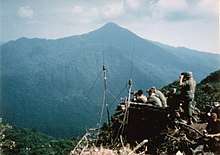
April 24, 1968. American Long Range Patrol soldiers on Dong Re Lao Mountain, which they dubbed Signal Hill, scanning for North Vietnamese vehicles in A Shau Valley below.
In April 1968, during the Vietnam War, the mountain was the site of an intense battle between members of the American 1st Cavalry Division, long-range reconnaissance patrol troops, and the North Vietnamese Army.[1] The mountain was dubbed "Signal Hill" by headquarters as it served as the lone radio relay site for American forces fighting in the valley during Operation Delaware.[2]
See also
- Battle of A Shau
- Battle of Signal Hill Vietnam
- Company E, 52nd Infantry (LRP)
- Long Range Reconnaissance Patrol
- Operation Delaware
References
- Lurps: A Ranger's Diary of Tet, Khe Sanh, A Shau, and Quang Tri, revised ed., Rowman & Littlefield Publishing Group, Lanham, MD, (2009).
- Lt. Gen. John Tolson, Vietnam Studies: Airmobility 1961–1971. Washington, DC: United States Government Printing Office (1973).
This article is issued from Wikipedia. The text is licensed under Creative Commons - Attribution - Sharealike. Additional terms may apply for the media files.