Dolwahal Dam
Dolwahal Dam, also called Weir Dam is an earthfill dam on Kundlika river near Roha, Raigad district in the state of Maharashtra in India.
| Dolwahal Dam | |
|---|---|
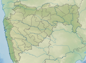
 Location of Dolwahal Dam in Maharashtra | |
| Official name | Dolwahal (Weir) Dam D03733 |
| Location | Roha |
| Coordinates | 18.426036°N 73.220412°E |
| Opening date | 1969[1] |
| Owner(s) | Government of Maharashtra, India |
| Dam and spillways | |
| Type of dam | Earthfill |
| Impounds | Kundlika river |
| Height | 12.5 m (41 ft) |
| Length | 543 m (1,781 ft) |
| Dam volume | 1,943 km3 (466 cu mi) |
| Reservoir | |
| Total capacity | 1,840 km3 (440 cu mi) |
| Surface area | 3,230 km2 (1,250 sq mi) |
Specifications
The height of the dam above lowest foundation is 12.5 m (41 ft) while the length is 543 m (1,781 ft). The volume content is 1,943 km3 (466 cu mi) and gross storage capacity is 10,070.00 km3 (2,415.92 cu mi).[2]
Purpose
- Irrigation
- Water Supply
gollark: Somehow designing the CLI is harder than writing the actual archiver code.
gollark: Discord bots are easy, machine learning is less easy.
gollark: *Do* you think I should actually store the compressed size? It would require either compressing to a temporary file and concatting it on later, or leaving some space in the pre-file-header bit to write it in after it's been compressed.
gollark: I "fixed" it, I just needed to enable single frame mode.
gollark: Arguably I should have some sort of "compressed size" field on it, but that would be work, so *instead* I'll just not do that and add on a length thing if it ever becomes necessary to not zstd-encode files.
See also
- Dams in Maharashtra
- List of reservoirs and dams in India
References
- "Dolwahal (Weir) D03733". Archived from the original on 12 April 2013. Retrieved 5 March 2013.
- Specifications of large dams in India Archived 21 July 2011 at the Wayback Machine
This article is issued from Wikipedia. The text is licensed under Creative Commons - Attribution - Sharealike. Additional terms may apply for the media files.