Dobra Kolata
Dobra Kolata (in Montenegrin and Serbian) or Kolata e Mirë (in Albanian) is a mountain in the Kolata massif located in Albania and Montenegro, part of the Prokletije, standing at 2,528 m (8,294 ft) high.[1][2]
| Dobra Kolata | |
|---|---|
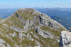 Dobra Kolata from summit Zla Kolata | |
| Highest point | |
| Elevation | 2,528 m (8,294 ft) |
| Coordinates | 42.4989°N 19.9°E |
| Geography | |
 Dobra Kolata Albania and Montenegro | |
Description
Dobra Kolata and Zla Kolata, which is 2,534 m (8,314 ft) high, are the two peaks of the Kolata massif located on the border. The highest peak is completely on Albanian territory and called Rodi e Kollatës, it rises 2,552 m (8,373 ft). Kolata is the second highest peak in Montenegro after its neighbour Zla Kolata.[1][2]
gollark: https://3c1703fe8d.site.internapcdn.net/newman/gfx/news/hires/2014/trfgyhcj.jpg
gollark: Because, really, it's players' *choice* whether they want to horribly break everything and/or use deprecated/stupid utilities.
gollark: Also, I would probably just add code to potatOS which:- unsetmetatables it- kills whoever added it
gollark: Fun skynet fact: the relay has an interface allowing you to check which players are online.
gollark: *should'ded
References
- Rudolf Abraham (30 November 2017). The Peaks of the Balkans Trail: Montenegro, Albania and Kosovo. Cicerone Press Limited. pp. 74–. ISBN 978-1-78362-555-0.
- Rachel Crolla; Carl McKeating (7 April 2014). Europe's High Points: Getting to the top in 50 countries. Cicerone Press. pp. 241–. ISBN 978-1-84965-960-4.
This article is issued from Wikipedia. The text is licensed under Creative Commons - Attribution - Sharealike. Additional terms may apply for the media files.