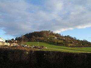
Dinedor Hill
Dinedor Hill is situated 2.5 miles south of Hereford. It is the site of Dinedor Camp, an Iron Age hillfort.
| Dinedor Hill | |
|---|---|
 Dinedor Camp | |
| Highest point | |
| Elevation | 182.88 m (600.0 ft) |
| Coordinates | 52.0235°N 2.6963°W |
| Geography | |
| Location | Herefordshire, England |
| OS grid | SO522363 |
| Topo map | OS Landranger 149 |
Further reading
- Children, G; Nash, G (1994) Prehistoric Sites of Herefordshire Logaston Press ISBN 1-873827-09-1
gollark: If it's actually enforced, the compliance requirements would kill off many tech businesses.
gollark: Look up the "online safety bill" over here.
gollark: There is a lot of political pressure about this sort of thing right now.
gollark: I'm not worried about false positives. I'm worried about the system existing in the first place.
gollark: https://www.bbc.co.uk/news/technology-58109748
External links
This article is issued from Wikipedia. The text is licensed under Creative Commons - Attribution - Sharealike. Additional terms may apply for the media files.