Delaware Route 44
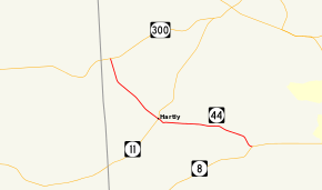
Delaware Route 44 (DE 44) is a state highway in Kent County, Delaware. It runs from DE 300 in Everetts Corner southeast to DE 8 in Pearsons Corner. The route passes through rural areas of western Kent County as well as the town of Hartly. In Hartly, it intersects DE 11. The route was built as a state highway east of Hartly by 1924 and west of Hartly by 1932, receiving the DE 44 designation by 1936.
| ||||
|---|---|---|---|---|
 | ||||
| Route information | ||||
| Maintained by DelDOT | ||||
| Length | 6.65 mi[1] (10.70 km) | |||
| Existed | 1936[2]–present | |||
| Major junctions | ||||
| West end | ||||
| East end | ||||
| Location | ||||
| Counties | Kent | |||
| Highway system | ||||
| ||||

Route description

DE 44 heads to the southeast of DE 300 in Everetts Corner on two-lane undivided Everetts Corner Road. The road passes through a mix of woodland and farmland before reaching the town of Hartly. In Hartly, the route intersects DE 11, where it becomes Main Street, and passes by homes along with some commercial establishments, crossing an abandoned railroad line. It then heads to the east out of Hartly on Hartly Road, passing through more rural areas. The route continues to its eastern terminus at DE 8 in Pearsons Corner.[3][4]
DE 44 has an annual average daily traffic count ranging from a high of 4,188 vehicles at the eastern terminus at DE 8 to a low of 1,565 vehicles at the western border of Hartly.[1] The entire length of DE 44 is part of the National Highway System.[5]
History
By 1920, what is now DE 44 existed as an unimproved county road.[6] The road east of Hartly was improved into a state highway by 1924.[7] By 1932, the portion of road west of Hartly became a state highway.[8] DE 44 was designated by 1936 to follow its current alignment.[2] The route has not changed since its inception.[3]
Major intersections
The entire route is in Kent County.
| Location | mi[1] | km | Destinations | Notes | |
|---|---|---|---|---|---|
| Everetts Corner | 0.00 | 0.00 | Western terminus | ||
| Hartly | 2.89 | 4.65 | |||
| Pearsons Corner | 6.65 | 10.70 | Eastern terminus | ||
| 1.000 mi = 1.609 km; 1.000 km = 0.621 mi | |||||
See also

References
- Staff (2018). "Traffic Count and Mileage Report: Interstate, Delaware, and US Routes" (PDF). Delaware Department of Transportation. Retrieved March 29, 2020.
- Delaware State Highway Department; The National Survey Co. (1936). Official Road Map of the State of Delaware (PDF) (Map) (1936–1937 ed.). Dover: Delaware State Highway Department. Retrieved November 24, 2015.
- Delaware Department of Transportation (2017). Official Travel & Transportation Map (PDF) (Map). Dover: Delaware Department of Transportation. Retrieved August 18, 2019.
- Google (August 20, 2010). "overview of Delaware Route 44" (Map). Google Maps. Google. Retrieved August 20, 2010.
- National Highway System: Delaware (PDF) (Map). Federal Highway Administration. 2010. Retrieved February 10, 2012.
- Delaware State Highway Department (1920). Official Road Map (PDF) (Map). Dover: Delaware State Highway Department. Retrieved November 24, 2015.
- Delaware State Highway Department (1924). Official Road Map (PDF) (Map). Dover: Delaware State Highway Department. Retrieved November 24, 2015.
- Delaware State Highway Department (1932). Official Road Map (PDF) (Map). Dover: Delaware State Highway Department. Retrieved November 24, 2015.
External links
