Delampady
Delampady is a village in Kasaragod district in the state of Kerala, India.[1]
Delampady | |
|---|---|
village | |
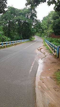
 Kottiyodi bridge | |
| Coordinates: 12.606430°N 75.277060°E | |
| Country | |
| State | Kerala |
| District | Kasaragod |
| Population (2001) | |
| • Total | 7,377 |
| Languages | |
| • Official | Tulu, Malayalam, English |
| Time zone | UTC+5:30 (IST) |
| Vehicle registration | KL-14 |

Demographics
As of the 2001 Indian census, Delampady had a population of 7377, 3749 of whom were male and 3628 of whom were female.[1]
Transportation
The western main road to Kasaragod have access to NH.66 which connects to Mangalore in the north and Calicut in the south. The road to the east connects to Sullia in Karnataka from where Mysore and Bangalore can be accessed. The nearest railway station is Kasaragod on Mangalore-Palakkad line. There is an airport at Mangalore.
Delampady is a Kerala village but it has no road access to Kerala. Delampady has an area of 89 sq.km. and 45% of the village is forest land. Delampady has 1457 houses and the total population is 6,000. There are nine roads for entering Delampadi and all of them are connected to Karnataka state only. The village territory is zigzagging between Kerala and Karnataka and at every 300 metres, you can find either a Kerala territory or a Karnataka territory. The only connection to Kerala is the two kilometre long forest track called Mayyala-Parappa road which is dangerous to walk because of the constant threat of moving herds of wild elephants. This road is six-metre wide but bus facility is not available because there is no tar surface on the road. This road is only two kilometre long but elephants are found almost all the time in this area.[2]
Facilities
Most of the people in Delampady depend upon Ishwaramangala village in Karnataka for their provisions. Adhur town is 13 km away and Mulleria town is 20 km away. Puttur City is 36 km away. Border villages in this locality include Kottyadi Bridge, Jalsoor Road, Pallathur Bridge, Parapa-Mudoor, Panchikkal, Kalladukka-Derkkaje, Ujjampadi-Munchikkan, Salathadukka-Panchuvadi, Kombode and Nunjubettu-Erikkadappu. There is a forest outpost at Kottyadi village. For emergency health issues, the people of Delampady village depend upon the small health centre located at Ujjampadi Anganavadi building.
The headquarters of the Delampady village is Adhur Town and the panchayath office is also located here. Almost all the government offices are also located in Adoor. The main agricultural activity of Delampady village is rubber plantation.[3]
References
- "Census of India : Villages with population 5000 & above". Registrar General & Census Commissioner, India. Archived from the original on 8 December 2008. Retrieved 10 December 2008.
- https://www.mathrubhumi.com/kasaragod/news/isolated-delambadi-karnataka-closed-the-nine-lanes-around-it-in-the-name-of-covid-19-1.4704763
- https://www.mathrubhumi.com/kasaragod/news/isolated-delambadi-karnataka-closed-the-nine-lanes-around-it-in-the-name-of-covid-19-1.4704763