Dehri
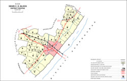
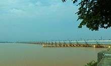
Dehri, also known as Dehri-on-Sone, is a metropolitan city and corresponding community development block in Rohtas district in the state of Bihar, India. Situated on the Son River, 16 km east of the district capital of Sasaram,[2] Dehri is a large industrial town and an important railway hub. As of 2011, its population was 137,231, in 23,234 households.[3] Dehri is home to the Indrapuri Barrage, the fourth-largest dam in the world.[4] It has also one of largest railway bridges of India over Sone River, approximately 4 km long. It is an education hub for villagers, and is also known for coal and sand mining.
Dehri Dehri-On-Sone | |
|---|---|
Urban Area | |
 | |
 Dehri Location in Bihar, India | |
| Coordinates: 24.91°N 84.18°E | |
| Country | |
| State | Bihar |
| District | Rohtas |
| Government | |
| • Type | Municipality |
| • Body | Dehri Urban Development Authority (DUDA) |
| Elevation | 52 m (171 ft) |
| Population | |
| • Total | 137,231 |
| Languages | |
| • Official | Hindi, Urdu |
| • Others | Bhojpuri, |
| Time zone | UTC+5:30 (IST) |
| PIN | 812307,821305[1] |
| Website | rohtas |
Demographics
| Year | Pop. | ±% |
|---|---|---|
| 1941 | 8,281 | — |
| 1951 | 24,406 | +194.7% |
| 1961 | 38,092 | +56.1% |
| 1971 | 46,037 | +20.9% |
| 1981 | 90,409 | +96.4% |
| 1991 | 93,594 | +3.5% |
| 2001 | 119,057 | +27.2% |
| 2011 | 137,231 | +15.3% |
| Source: 2011 Census of India[3] | ||
According to the 2011 Census, Dehri had a population of 137,231. Males were 72,372 and females 64,859. The average literacy rate was 81.2%, higher than the national average of 74%. Male literacy was 87.54% and female literacy 74.08%. The population of children in age group 0–6 years was 19,010, of which boys were 9,886 and girls 9,124.
Economy

Important industries in Dehri include sugar production, sawmilling, ghee processing, and cement manufacturing.[2] Other important commodities include plastic pipes, light bulbs, and shoes.[3]
The headworks of the Son canal system is located in Dehri.[2][3]
Recreation
Dehri is home to a stadium, five cinemas, four auditoriums, and three public libraries.[3]
Villages
The CD block of Dehri contains 58 rural villages, all of which are inhabited:[3]
| Village name | Total land area (hectares) | Population (in 2011) |
|---|---|---|
| Panruhar | 557 | 1,803 |
| Gohi | 123 | 1,353 |
| Gonuwan | 69 | 720 |
| Maudiha | 136 | 1,727 |
| Shiwpur | 78 | 590 |
| Barawan | 279 | 4,521 |
| Ahirawan | 176 | 1,942 |
| Khudrawan | 120 | 1,439 |
| Chilbila | 97 | 1,380 |
| Parsawan | 55 | 1,307 |
| Tanrwa | 210 | 1,177 |
| Majhiawan | 195 | 1,839 |
| Ayar Kotha | 53 | 1,138 |
| Darihat | 1,123 | 11,953 |
| Bhusahula | 291 | 2,953 |
| Chainpur | 311 | 876 |
| Berkap | 454 | 2,893 |
| Bharkunria | 184 | 1,885 |
| Ahibaranpur | 121 | 2,065 |
| Hurka | 320 | 1,982 |
| Sidhauli | 22 | 2,320 |
| Gangauli | 447 | 5,279 |
| Pahleza | 338 | 6,464 |
| Shiupur | 59 | 932 |
| Deuria | 284 | 2,939 |
| Tendua Dusadhi | 239 | 2,660 |
| Mahdewa | 175 | 1,298 |
| Chormara | 74 | 25 |
| Jamuhar | 368 | 6,228 |
| Rudarpura | 210 | 1,121 |
| Chakia | 264 | 2,362 |
| Manaura | 70 | 625 |
| Mathuri | 180 | 3,581 |
| Sakhara | 405 | 5,820 |
| Suara | 267 | 2,584 |
| Dahaur | 276 | 2,802 |
| Patpura | 219 | 1,617 |
| Bharkunria | 320 | 1,737 |
| Guraila | 146 | 1,933 |
| Durgapur | 170 | 1,461 |
| Bhatauli | 162 | 1,558 |
| Wojhaulia | 19 | 731 |
| Ghonghaha | 96 | 1,865 |
| Khairaha | 135 | 1,853 |
| Bhainsaha | 64 | 2,833 |
| Bastipur | 451 | 2,159 |
| Katar | 853 | 3,368 |
| Bardiha | 94 | 1,477 |
| Sujanpur | 109 | 1,750 |
| Manikpur | 53 | 1,814 |
| Bhaluari | 475 | 6,821 |
| Nawadih | 422 | 4,000 |
| Dudhmi | 134 | 1,705 |
| Shahpur | 103 | 89 |
| Chaknaha | 155 | 1,831 |
| Shankarpur | 120 | 2,056 |
| Sikaria | 619 | 559 |
| Patanawa | 528 | 1,983 |
References
- Dehri on Sone Rohtas Pin Code, citypincode.in
- "Dehri". Encyclopaedia Britannica. Retrieved 21 May 2020.
- "Census of India 2011: Bihar District Census Handbook - Rohtas, Part A (Village and Town Directory)". Census 2011 India. pp. 33, 44–70, 1084–1123, 1191–1192, 1286–1299. Retrieved 20 May 2020.
- "Indrapuri Dam". Rohtas District. Retrieved 21 May 2020.