Deering Airport
Deering Airport (IATA: DRG, ICAO: PADE, FAA LID: DEE) is a state-owned public-use airport located two nautical miles (3.7 km) southwest of the central business district of Deering,[1] a city in the Northwest Arctic Borough of the U.S. state of Alaska.
Deering Airport | |||||||||||||||
|---|---|---|---|---|---|---|---|---|---|---|---|---|---|---|---|
 | |||||||||||||||
| Summary | |||||||||||||||
| Airport type | Public | ||||||||||||||
| Owner | State of Alaska DOT&PF - Northern Region | ||||||||||||||
| Serves | Deering, Alaska | ||||||||||||||
| Elevation AMSL | 21 ft / 6 m | ||||||||||||||
| Coordinates | 66°04′10″N 162°45′59″W | ||||||||||||||
| Runways | |||||||||||||||
| |||||||||||||||
| Statistics (2016) | |||||||||||||||
| |||||||||||||||
Although most U.S. airports use the same three-letter location identifier for the FAA and IATA, this airport is assigned DEE by the FAA[1] and DRG by the IATA.[3] The airport's ICAO identifier is PADE.[4]
Facilities
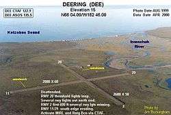
Deering Airport covers an area of 262 acres (106 ha) at an elevation of 21 feet (6 m) above mean sea level. It has two gravel surfaced runways: 2/20 measures 3,300 by 75 feet (1,006 x 23 m) and 11/29 is 2,640 by 75 feet (805 x 23 m).[1]
Airlines and destinations
| Airlines | Destinations |
|---|---|
| Bering Air | Buckland, Kotzebue[5] |
Prior to its bankruptcy and cessation of all operations, Ravn Alaska served the airport from multiple locations.
Statistics
| Carrier | Passengers (arriving and departing) |
|---|---|
| Bering | 1,620(67.25%) |
| Hageland | 790(32.75%) |
| Rank | City | Airport | Passengers |
|---|---|---|---|
| 1 | Ralph Wien Memorial Airport | 1,000 | |
| 2 | Buckland Airport | 180 | |
| 3 | Nome Airport | 10 |
References
- FAA Airport Master Record for DEE (Form 5010 PDF), effective April 27, 2017.
- "Deering, AK: Deering (DEE)". Bureau of Transportation Statistics (BTS), Research and Innovative Technology Administration (RITA), U.S. Department of Transportation. December 2016. Retrieved May 5, 2017.
- Great Circle Mapper: DRG / PADE - Deering, Alaska
- "Alaskan ICAO Identifiers". Federal Aviation Administration. Archived from the original on 2009-07-28. Retrieved 2009-08-07.
- "Bering Air Schedule" (PDF). Bering Air. Retrieved January 15, 2017.
External links
- FAA Alaska airport diagram (GIF)
- FAA Terminal Procedures for DEE, effective July 16, 2020
- Resources for this airport:
- FAA airport information for DEE
- AirNav airport information for PADE
- ASN accident history for DRG
- FlightAware airport information and live flight tracker
- NOAA/NWS latest weather observations for PADE
- SkyVector aeronautical chart for DEE