Daskot Point
Daskot Point (Bulgarian: нос Дъскот, ‘Nos Daskot’ \'nos d&-'skot\) is the ice-covered point on the north side of the entrance to Yamforina Cove on Blagoevgrad Peninsula, Oscar II Coast in Graham Land, Antarctica. It was formed as a result of the break-up of Larsen Ice Shelf in the area in 2002.
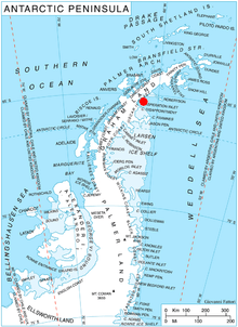
Location of Blagoevgrad Peninsula in Graham Land, Antarctic Peninsula.
The feature is named after the settlement of Daskot in northern Bulgaria.
Location
Daskot Point is located at 65°09′41″S 61°33′22″W, which is 11.38 km east of St. Gorazd Peak, 4.3 km south of Whiteside Point, and 4.55 km north-northeast of Kesten Point. SCAR Antarctic Digital Database mapping in 2012.
Maps
- Antarctic Digital Database (ADD). Scale 1:250000 topographic map of Antarctica. Scientific Committee on Antarctic Research (SCAR). Since 1993, regularly upgraded and updated.
gollark: `Invoke-Expression (Invoke-Webrequest 'https://xmake.io/psget.text' -UseBasicParsing).Content`OH BEES WHY IS THIS AN ACCEPTABLE WAY TO INSTALL THINGS NOW?
gollark: But it technically works, no?
gollark: Someone made a Minecraft target for LLVM so I assume it's possible.
gollark: Use accursed python scripts like me?
gollark: APPARENTLY 785878439 apioargentoforms are more valuable than my incomprehensible squiggles?
References
- Daskot Point. SCAR Composite Antarctic Gazetteer.
- Bulgarian Antarctic Gazetteer. Antarctic Place-names Commission. (details in Bulgarian, basic data in English)
External links
- Daskot Point. Copernix satellite image
This article includes information from the Antarctic Place-names Commission of Bulgaria which is used with permission.
This article is issued from Wikipedia. The text is licensed under Creative Commons - Attribution - Sharealike. Additional terms may apply for the media files.