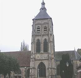
Damville, Eure
Damville is a former commune in the Eure Department in the Normandy region in northern France. On 1 January 2016, it was merged into the new commune of Mesnils-sur-Iton.[2]
Damville | |
|---|---|
Part of Mesnils-sur-Iton | |
 | |
.svg.png) Coat of arms | |
Location of Damville 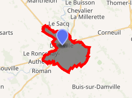
| |
 Damville  Damville | |
| Coordinates: 48°52′14″N 1°04′32″E | |
| Country | France |
| Region | Normandy |
| Department | Eure |
| Arrondissement | Bernay |
| Canton | Verneuil-sur-Avre |
| Commune | Mesnils-sur-Iton |
| Area 1 | 11.74 km2 (4.53 sq mi) |
| Population (2013)[1] | 2,016 |
| • Density | 170/km2 (440/sq mi) |
| Time zone | UTC+01:00 (CET) |
| • Summer (DST) | UTC+02:00 (CEST) |
| Postal code | 27240 |
| Elevation | 130–164 m (427–538 ft) (avg. 145 m or 476 ft) |
| 1 French Land Register data, which excludes lakes, ponds, glaciers > 1 km2 (0.386 sq mi or 247 acres) and river estuaries. | |
Population
| Year | Pop. | ±% |
|---|---|---|
| 1868 | 985 | — |
| 1962 | 1,321 | +34.1% |
| 1968 | 1,349 | +2.1% |
| 1975 | 1,345 | −0.3% |
| 1982 | 1,666 | +23.9% |
| 1990 | 1,897 | +13.9% |
| 1999 | 2,017 | +6.3% |
| 2008 | 2,031 | +0.7% |
History
In the Middle Ages, Damville was important for its situation on the Norman border. The fortress of Damville was built in 1035. The castle was burned down by Henry II of England, in 1189, it was rebuilt by Richard the Lionheart.
Personalities
- Raymond Duchamp-Villon (1876–1918), sculptor
- Jacques Villon (Gaston Duchamp) (1875–1963), painter, draughtsman and engraver.
- Michel Cluizel, chocolate factory founder
- André Couteaux, French novelist
gollark: This site is so poorly programmed.
gollark: So, I still can't convince the SYSTEM™ to make you an admin.
gollark: Unfortunately, it won't let me make you admin.
gollark: Very odd!
gollark: I haven't edited anything, but the response says you do.
See also
References
- Populations légales 2013: Téléchargement du fichier d'ensemble, INSEE
- Arrêté préfectoral 23 November 2015 (in French)
| Wikimedia Commons has media related to Damville. |
| Authority control |
|
|---|
This article is issued from Wikipedia. The text is licensed under Creative Commons - Attribution - Sharealike. Additional terms may apply for the media files.