Daleli
Daleli Bajar is a village in the Kanepokhari Rural Municipality in the Morang District of Province No. 1, south-eastern Nepal. It is in Kanepokhari Ward 2, which had a population of 5,941 in 2011.
Daleli | |
|---|---|
Village | |
 Kanepokhari. Daleli is in Ward 2. | |
| Coordinates: 26.553513°N 87.494360°E | |
| Country | |
| Province | Province No. 1 |
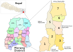
| District | Morang District |
| Gaunpalika | Kanepokhari |
| Population (1991) | |
| • Total | 10,802 |
| Time zone | UTC+5:45 (Nepal Time) |
Location
Daleli is in Nepal, Province 1, Morang, Kanepokhari. The elevation is about 891 metres (2,923 ft) above sea level.[1] The Köppen climate classification is Cwa: Monsoon-influenced humid subtropical climate.[2]
Google Maps shows Daleli on the Kanepokhari–Rangeli Road, south of Keroun Bazar.[3]
Daleli was in Keroun Ward 9. It is now in Kanepokhari Ward 2.[4] As of 2011 Kanepokhari Ward 2 had 1,368 households with a population of 5,941, of which 2,758 were male and 3,183 were female.[5]
The school Sikshya Bikash Ma V is in Kanepokhari-2, Daleli, Morang.[4]
References
- "Daleli Bajar", GeoNames
- "Daleli Bajar, Keroun, Morang, Kosī Zone, Purwanchal, Nepal", Mindat, retrieved 2020-06-11
- "Daleli", Google Maps, retrieved 2020-06-11
- School Details vy Local Level and District, 2076 (PDF), p. 18, retrieved 2020-06-11
- Unit-9: Kanepokhari Gaunpalika (PDF), District Coordination Committee Office : Morang, Nepal, p. 10, retrieved 2020-06-11
Headquarter: Biratnagar | ||
| Metropolitan City | 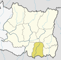 | |
| Municipalities | ||
| Rural Municipalities | ||