Dakataua
The Dakataua Caldera is located at the northern tip of the Willaumez Peninsula, New Britain, Papua New Guinea. The peninsula includes the 350 m high andesitic Mount Makalia stratovolcano. [1]
| Dakataua | |
|---|---|
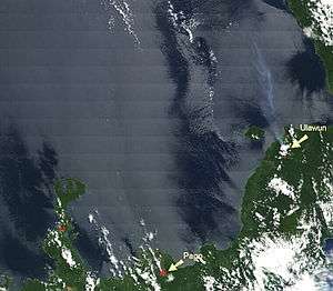 Dakataua lake on the North tip of the Willaumez Peninsula, left of the Pago volcano. On the right there is a steam plume over the sea from the Ulawun volcano. | |
| Highest point | |
| Elevation | 400 m (1,300 ft) |
| Coordinates | 5°3′20″S 150°6′30″E |
| Geography | |
 Dakataua | |
| Geology | |
| Mountain type | Stratovolcano |
| Volcanic arc/belt | Bismarck volcanic arc |
| Last eruption | 1895 ± 5 years |
Caldera lake
Dakataua caldera lake is about 76 m above sea level, has total surface area 48 km2 (19 sq mi), and the maximum depth approximately 120 m. [2]
gollark: Possibly? I'd expect there's another way.
gollark: EFI, I mean.
gollark: I'm not sure if it actually has drawing commands outside of terminal-ish stuff.
gollark: Or probably `periodictable[elem]`, I doubt they would do it that weirdly.
gollark: Just use getattr or something.
References
- Dakataua Global Volcanism Program · Department of Mineral Sciences · National Museum of Natural History Smithsonian Institution © 2013
- E. BALL, J. GLUCKSMAN A limnological survey of Lake Dakataua, a large calderalake on West New Britain, Papua New Guinea, with comparisons to Lake Wisdom, a younger nearby caldera lake. Freshwater Biology (10)73, 1980
This article is issued from Wikipedia. The text is licensed under Creative Commons - Attribution - Sharealike. Additional terms may apply for the media files.