Daer Reservoir
Daer Reservoir is a man-made waterbody created by the damming of the Daer Water, a tributary of the River Clyde in the Southern Uplands of Scotland. It lies within the Lowther Hills in South Lanarkshire. A minor public road leaving the A702 follows the Daer Water south to the dam and then continues along the western margin of the reservoir as far as Kirkhope.[1] The reservoir was officially opened by HM Queen Elizabeth II in 1956 to supply water to the Scottish Central Belt.[2]
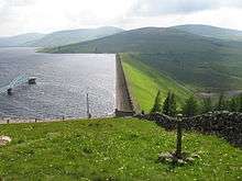
Daer Reservoir and dam
Recreation
Season tickets for fishing in the reservoir for brown trout are available from Kilbryde Angling Club.[3] The Southern Upland Way passes just to the north of the dam and affords views over the reservoir for the walker. [4]
gollark: It's a competitor.
gollark: ... Bing?
gollark: I wanted to use it but annoying dependency things of some kind.
gollark: I've seen at least one.
gollark: Cool.
References
- Ordnance Survey 1:25,000 scale Explorer map sheet no 329 Lowther Hills, Sanquhar & Leadhills
- "Daer Reservoir". Biggararchaeology.org.uk. Archived from the original on 2015-07-14. Retrieved 2015-07-13.
- "Fishing in Strathclyde - Scotland". Archived from the original on August 19, 2011. Retrieved September 14, 2011.
- "Map 56 Daer Reservoir South Getting outdoors - South Lanarkshire Council". Southlanarkshire.gov.uk. 2014-09-19. Retrieved 2015-07-13.
This article is issued from Wikipedia. The text is licensed under Creative Commons - Attribution - Sharealike. Additional terms may apply for the media files.