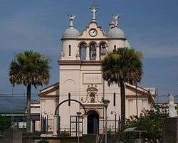
Curridabat
Curridabat is a district in the Curridabat canton of the San José Province in Costa Rica.[1]
Curridabat | |
|---|---|
District | |
 | |
 Coat of arms | |
| Nickname(s): Curri | |
| Coordinates: 09°56′N 84°05′W | |
| Country | Costa Rica |
| Province | San José Province |
| Canton | Curridabat |
| Founded | 1929 |
| Government | |
| • Syndic | Ana Lucía Ferrero Mata (Curridabat Siglo XXI) |
| • Substitute syndic | Álvaro Enrique Chaves Lizano |
| Area | |
| • Total | 6.48 km2 (2.50 sq mi) |
| Elevation | 1,208 m (3,963 ft) |
| Population (2012) | |
| • Total | 32,443 |
| • Density | 5,000/km2 (13,000/sq mi) |
| • Demonym | Curridabatense |
| Time zone | UTC-6 (Central Standard Time) |
| Postal code | 11801 |
| Area code(s) | + 506 |
It is situated on the eastern border of the city, San José, above the Desamparados Canton, and below the Montes de Oca Canton.
References
- "Municipalidad de Curridabat". Retrieved 16 May 2020.
External links
- General information about Curridabat, including maps (in Spanish)
- Government site (in Spanish)
| Wikimedia Commons has media related to Curridabat. |
This article is issued from Wikipedia. The text is licensed under Creative Commons - Attribution - Sharealike. Additional terms may apply for the media files.