Cultural monuments in Lichte
This is a list of the cultural monuments in Lichte containing all cultural monuments of the Thuringian municipality of Lichte / Lichtetal am Rennsteig (district of Saalfeld-Rudolstadt), including its sections (Bock-und-Teich, Geiersthal, Lichte and Wallendorf) as of December 2, 2009.
Single monuments in Lichte
| Picture | Description | Municipal section; location | Remark |
|---|---|---|---|
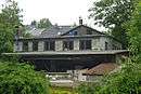
.jpg) | Lichte (Thuringia) east station | Lichte (Wallendorf), Am Bahndamm 9 | closed 1997 |
 | Lichte (Wallendorf), cemetery | nearby church | |
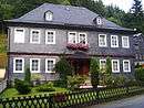
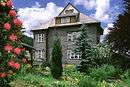
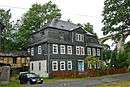 | Historical manor-house | Lichte (Wallendorf), Hammerweg 2 | with adjoining building, grounds and enclosure |
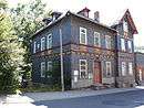
 | Historical residential premises | Lichte (Wallendorf), Hammerweg 3 | belonging to the manor-house |
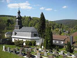 | Saalfelder Str. 32 in Wallendorf | Lichte (Wallendorf), Kirchweg | Evangelical church dating to 1734 |
 | Parish house | Lichte (Wallendorf), Lamprechtstrasse 12 | Vicarage |
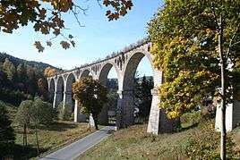 | Railway viaduct over the Piesau | Lichte (Wallendorf), Saalfelder Str. | closed 1997 |
 | Post office | Lichte (Wallendorf), Saalfelder Str. 8 | |
 | historical "Post Hotel" | Lichte (Wallendorf), Saalfelder Str. 32 | closed |
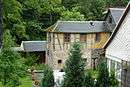
| Sawmill | Schmidtenhof | historical Geiersthal trip hammer | |
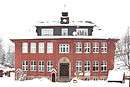
 | Historical school building | Geiersthal; Schulweg 16 | 1920s, today drafting and model-making school (Homepage of the school) |
 | historical Perlen-Heinz villa (1908) | Lichte (Geiersthal), Schwarzburger Str. 70 | property & residence of factory-owning Heinz/Wiesser family |
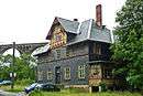
 | Historical sawmill | Lichte (Unterlichte), Sonneberger Str. 57 | |
 | Kindergarten | Lichte (Oberlichte), Sonneberger Str. 70 | former Lichte school |
Monuments to the casualties of the World Wars
Monuments of World War II
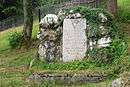
- Lichte (Wallendorf) cemetery: memorial graves for 4 Polish forced labourers
- Lichte cemetery: Memorial plaque to 2 victims of the forced march of inmates from Buchenwald concentration camp in April 1945, who were found in the Finsterer Grund under the rail viaduct.[1]
gollark: I just use a bunch of Markdown files, personally.
gollark: PotatOS has users, some of them unwillingly.
gollark: There's still one pesky unpatched sandbox exploit.
gollark: PotatOS is designed to make it as hard as possible to meddle much in the internals if you're a user.
gollark: PotatOS uses the Polychoron process manager I made, but it's not hooked into multishell or anything.
References
- Thüringer Verband der Verfolgten des Naziregimes - Bund der Antifaschisten und Studienkreis deutscher Widerstand 1933-1945 (Ed.), Heimatgeschichtlicher Wegweiser zu Stätten des Widerstandes und der Verfolgung 1933-1945, Volume 8 Thüringen, Erfurt, 2003, ISBN 3-88864-343-0, p. 237 (in German)
External links
- Denkmalliste des Landkreises Saalfeld-Rudolstadt, December 2, 2009 (pdf) (in German)
This article is issued from Wikipedia. The text is licensed under Creative Commons - Attribution - Sharealike. Additional terms may apply for the media files.