Cuartero, Capiz
Cuartero, officially the Municipality of Cuartero (Capiznon/Hiligaynon: Banwa sang Cuartero; Tagalog: Bayan ng Cuartero), is a 4th class municipality in the province of Capiz, Philippines. According to the 2015 census, it has a population of 27,408 people.[4]
Cuartero | |
|---|---|
| Municipality of Cuartero | |
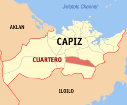
 Map of Capiz with Cuartero highlighted | |
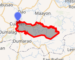
OpenStreetMap 
| |
.svg.png) Cuartero Location within the Philippines | |
| Coordinates: 11°21′N 122°40′E | |
| Country | |
| Region | Western Visayas (Region VI) |
| Province | Capiz |
| District | 2nd district of Capiz |
| Barangays | 22 (see Barangays) |
| Government | |
| • Type | Sangguniang Bayan |
| • Mayor | Tito L. Mayo |
| • Vice Mayor | Roger F. Flores |
| • Congressman | Fredenil H. Castro |
| • Electorate | 19,544 voters (2019)[2] |
| Area | |
| • Total | 106.58 km2 (41.15 sq mi) |
| Population (2015 census)[4] | |
| • Total | 27,408 |
| • Density | 260/km2 (670/sq mi) |
| • Households | 6,428 |
| Economy | |
| • Income class | 4th municipal income class |
| • Poverty incidence | 19.35% (2015)[5] |
| • Revenue (₱) | 81,105,318.34 (2016) |
| Time zone | UTC+8 (PST) |
| ZIP code | 5811 |
| PSGC | |
| IDD : area code | +63 (0)36 |
| Climate type | tropical climate |
| Native languages | Capiznon Hiligaynon Tagalog |
| Website | www |
Geography
Cuartero is 37 kilometres (23 mi) from Roxas City.
Barangays
Cuartero is politically subdivided into 22 barangays. [3]
- Agcabugao
- Agdahon
- Agnaga
- Angub
- Balingasag
- Bito-on Ilawod
- Bito-on Ilaya
- Bun-od
- Carataya
- Lunayan
- Mahunodhunod
- Maindang
- Mainit
- Malagab-i
- Nagba
- Poblacion Ilawod
- Poblacion Ilaya
- Poblacion Takas
- Puti-an
- San Antonio
- Sinabsaban
- Mahabang Sapa
Climate
| Climate data for Cuartero, Capiz | |||||||||||||
|---|---|---|---|---|---|---|---|---|---|---|---|---|---|
| Month | Jan | Feb | Mar | Apr | May | Jun | Jul | Aug | Sep | Oct | Nov | Dec | Year |
| Average high °C (°F) | 27 (81) |
28 (82) |
29 (84) |
31 (88) |
32 (90) |
31 (88) |
30 (86) |
30 (86) |
29 (84) |
29 (84) |
29 (84) |
27 (81) |
29 (85) |
| Average low °C (°F) | 23 (73) |
23 (73) |
23 (73) |
24 (75) |
25 (77) |
25 (77) |
24 (75) |
24 (75) |
24 (75) |
24 (75) |
24 (75) |
23 (73) |
24 (75) |
| Average precipitation mm (inches) | 61 (2.4) |
39 (1.5) |
46 (1.8) |
48 (1.9) |
90 (3.5) |
144 (5.7) |
152 (6.0) |
145 (5.7) |
163 (6.4) |
160 (6.3) |
120 (4.7) |
90 (3.5) |
1,258 (49.4) |
| Average rainy days | 12.3 | 9.0 | 9.9 | 10.0 | 18.5 | 25.0 | 27.4 | 26.0 | 25.9 | 24.9 | 17.9 | 14.2 | 221 |
| Source: Meteoblue (modeled/calculated data, not measured locally) [6] | |||||||||||||
Demographics
|
| |||||||||||||||||||||||||||||||||||||||
| Source: Philippine Statistics Authority[4][7][8][9] | ||||||||||||||||||||||||||||||||||||||||
In the 2015 census, the population of Cuartero, Capiz, was 27,408 people,[4] with a density of 260 inhabitants per square kilometre or 670 inhabitants per square mile.
gollark: Plus many, many other small changes over the millenia.
gollark: Replayability of halloween thing.
gollark: Making it automatic is more effort than ignoring it!
gollark: Not really.
gollark: It could be done automatically, but that'd take a significant amount of effort.
References
- "Municipality". Quezon City, Philippines: Department of the Interior and Local Government. Retrieved 31 May 2013.
- {{https://www.comelec.gov.ph/php-tpls-attachments/2019NLE/Statistics/NumofRegVoterbySexbyCityMun.pdf}}
- "Province: Capiz". PSGC Interactive. Quezon City, Philippines: Philippine Statistics Authority. Retrieved 12 November 2016.
- Census of Population (2015). "Region VI (Western Visayas)". Total Population by Province, City, Municipality and Barangay. PSA. Retrieved 20 June 2016.
- "PSA releases the 2015 Municipal and City Level Poverty Estimates". Quezon City, Philippines. Retrieved 12 October 2019.
- "Cuartero: Average Temperatures and Rainfall". Meteoblue. Retrieved 2 May 2020.
- Census of Population and Housing (2010). "Region VI (Western Visayas)". Total Population by Province, City, Municipality and Barangay. NSO. Retrieved 29 June 2016.
- Censuses of Population (1903–2007). "Region VI (Western Visayas)". Table 1. Population Enumerated in Various Censuses by Province/Highly Urbanized City: 1903 to 2007. NSO.
- "Province of Capiz". Municipality Population Data. Local Water Utilities Administration Research Division. Retrieved 17 December 2016.
External links
This article is issued from Wikipedia. The text is licensed under Creative Commons - Attribution - Sharealike. Additional terms may apply for the media files.