Cruser Brook
Cruser Brook, also known as Crusers Brook,[1] is a tributary of Pike Run in Somerset County, New Jersey in the United States.[2]
| Cruser Brook | |
|---|---|
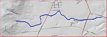 Map of Cruser Brook | |
| Location | |
| Country | United States |
| Physical characteristics | |
| Source | |
| • coordinates | 40°26′47″N 74°42′17″W |
| Mouth | |
• coordinates | 40°27′20″N 74°39′4″W |
• elevation | 52 ft (16 m) |
| Basin features | |
| Progression | Pike Run, Beden Brook, Millstone River, Raritan River, Atlantic Ocean |
| Tributaries | |
| • left | Roaring Brook |
Course
Cruser Brook starts at 40°26′47″N 74°42′17″W[1] in Sourland Mountain. It flows northeast and picks up Roaring Brook. It crosses CR-601 (Belle Mead-Blawenburg Road) and continues flowing east. It crosses Route 206 and drains into Pike Run at 40°27′20″N 74°39′4″W.[1]
Tributaries
- Roaring Brook
Sister Tributaries
gollark: Is this in craftOS-PC?
gollark: 921, you say?
gollark: <@231856503756161025> <@231856503756161025> <@231856503756161025> <@231856503756161025> <@231856503756161025>
gollark: Screenshotoform?
gollark: Assertion WHERE, apio?
See also
References
- "GNIS Detail - Cruser Brook". USGS. Retrieved 21 July 2010.
- "Cruser Brook in Somerset County, New Jersey". AnyPlaceAmerica. Archived from the original on 18 July 2012. Retrieved 21 July 2010.
This article is issued from Wikipedia. The text is licensed under Creative Commons - Attribution - Sharealike. Additional terms may apply for the media files.