Cowcumbala, New South Wales
Cowcumbala, New South Wales is a rural locality and civil parish of Harden County, New South Wales.[1][2][3]
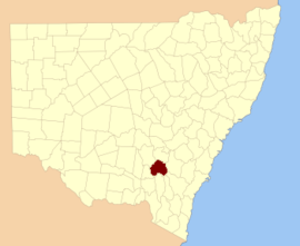
Harden County
The parish of Cowcumbala is located at 34°43'54.0"S 148°04'04.0"E on the Main Southern railway line, New South Wales. The nearest town is Cootamundra to the north. Cowcumbala is on the traditional lands of the Wiradjuri people.
References
- Robert McLean, The New atlas of Australia : the complete work containing over one hundred maps and full descriptive geography of New South Wales, Victoria, Queensland, South Australia and Western Australia, together with numerous illustrations and copious indices (Sydney :J. Sands, [1886) Map 11.
- "Harden County". Geographical Names Register (GNR) of NSW. Geographical Names Board of New South Wales.

- County of Cowley and Co. Buccleuch New South Wales, 1871 map, County of Cowley and Co. Buccleuch New South Wales, 1871 map.
This article is issued from Wikipedia. The text is licensed under Creative Commons - Attribution - Sharealike. Additional terms may apply for the media files.