Corserine
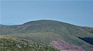
Corserine is a hill in the Rhinns of Kells range, part of the Southern Uplands of Scotland. The highest point of the range and the second highest point in Galloway, the usual route of ascent is from the car park at Forrest Lodge to the east of the hill via Loch Harrow and North Gairy Top. Forest Lodge is a short drive from the village of St. John's Town of Dalry.
| Corserine | |
|---|---|
 | |
| Highest point | |
| Elevation | 814 m (2,671 ft) [1] |
| Prominence | 488 m (1,601 ft) [2] |
| Listing | Ma,Hu,Tu,Sim, C, D,DN,Y[3] |
| Naming | |
| English translation | Scots, Scottish Gaelic: 'Cross of the promontory' |
| Geography | |
| Location | Dumfries and Galloway, Scotland |
| Parent range | Rhinns of Kells, Galloway Hills, Southern Uplands |
| OS grid | NX 49784 87065 |
| Topo map | OS Landranger 77 |
Climbing
Because of the nature of the rock no good rock climbing has been recorded on Corserine or elsewhere on the Rhinns. However, in winter after a good freeze there are a number of good ice climbs of up to 150 m on the slopes of Milldown just south of Corserine.[4]
gollark: ~£120 or so for the calculator, my phone was £80.
gollark: For what?
gollark: They literally cost more than my (low-end, yes) *smartphone*.
gollark: Ah yes, buying a calculator which costs more than a phone.
gollark: That would be not uncool.
External links
References
- https://www.hill-bagging.co.uk/mountaindetails.php?qu=S&rf=1689
- https://www.hill-bagging.co.uk/mountaindetails.php?qu=S&rf=1689
- http://www.hills-database.co.uk/database_notes.html#classification
- John Biggar. "Rhinns of Kells". Archived from the original on 2007-10-26. Retrieved 2007-06-14.
This article is issued from Wikipedia. The text is licensed under Creative Commons - Attribution - Sharealike. Additional terms may apply for the media files.