Corfe River
The Corfe River is one of the four main rivers flowing into Poole Harbour in the county of Dorset, England. It is just under 9 kilometres long.[2]
| Corfe River | |
|---|---|
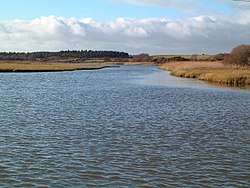 Mouth of Corfe River at Wych Lake | |
| Physical characteristics | |
| Source | |
| • location | North Egliston, about 1.5 km W of Steeple, Isle of Purbeck |
| • coordinates | 50.62510°N 2.12821°W |
| • elevation | 85 m (279 ft)[1] |
| Mouth | |
• location | Wych Lake, Poole Harbour |
• elevation | 0 m (0 ft) |
| Length | 8.805 km (5.471 mi)[2] |
| Basin size | 33.922 km2 (13.097 sq mi)[2] |
Name
The Saxon name for Corfe River was the Wichen; this survives in the names of Wytch Farm, Upper Wych Channel, Wytch Heath and Wytch, or Wych, Lake. Wichen may have derived from wics which meant "dairy farm", an indication that the area may not always have been heathland.[3]
Course
The Corfe River rises near North Egliston about 1.5 km (1 mi) west of the hamlet of Steeple, between the Purbeck Hills and the coastal ridge. The river initially flows eastwards towards Corfe Castle. Just before reaching the village it swings north-northeast through the gap in the Purbecks between West Hill and East Hill and continues across Wytch Heath before emptying into Wych (or Wytch) Lake on the southern side of Poole Harbour.[1][2]
Water quality
In 2013 the Corfe River's water body quality was graded overall "poor" by the Environment Agency.[2]
References
- OS topographic map, 1:25,000 series, No. OL15 Purbeck & South Dorset.
- Corfe River at environment.data.gov.uk. Retrieved 6 Nov 2016.
- Bruce, Peter. Inshore Along the Dorset Coast. Lymington, Boldre Marine, 2008. p. 23.