Coonamia railway station
Coonamia railway station was a "provisional stopping place" in the rural locality of the same name, 5.0 km (3.1 mi) by rail south-east of the centre of the city of Port Pirie, South Australia. It was operational for two separate periods:
- on the narrow-gauge route to Gladstone, from 1929 until an unknown date before 1970, when it closed
- on the same route (by then standard-gauge), from 1989 to the early 2010s, when it was the sixth and final place for passengers to board and alight trains at Port Pirie.
Coonamia "provisional stopping place" | |||||||||||||||||||
|---|---|---|---|---|---|---|---|---|---|---|---|---|---|---|---|---|---|---|---|
.jpg) Site of the former Coonamia stopping place in 2020. Trains no longer stop there; the sign now only marks the boundary of two train control districts. The round structure houses railway signalling and communication equipment unconnected with the stopping place. | |||||||||||||||||||
| Location | Railway Terrace South (corner of Hillview Road), Coonamia, near Port Pirie, South Australia | ||||||||||||||||||
| Coordinates | 33°11′42″S 138°03′02″E [1][note 1] | ||||||||||||||||||
| Owned by | Successively: | ||||||||||||||||||
| Line(s) |
| ||||||||||||||||||
| |||||||||||||||||||
The stopping place was on Railway Terrace South, near its intersection with Old Race Course Road (now called Hillview Road). The South Australian Railways included it in timetables from about 1929 on the narrow-gauge railway line leading into the hinterland from Port Pirie. It was instituted for local passengers to board and alight trains without having to walk to the station at Port Pirie South.
Infrastructure was meagre: only a waiting shed and sign. There was no platform, as for all stations in the Mid North of South Australia at the time. Trains did not stop there unless a passenger signalled the driver to stop or notified the guard to be let off – indicated by an asterisk on timetables and its classification as a "provisional stopping place".[2]
In 1937 a new, more direct, broad-gauge line from Adelaide followed a different route that bypassed Coonamia. The number of passengers using the stopping place declined further and it was eventually closed.[3]
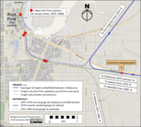
In 1989, the last major Port Pirie station (Mary Elie Street) closed. It was necessary to provide a facility for Port Pirie passengers — not for services to Adelaide, since all South Australian intrastate country passenger services were discontinued that year — but for interstate trains that passed through. The trains involved were The Ghan, Indian Pacific and (until June 1991) the Trans-Australian.[4][5] [note 2] As shown on the map, having a stop at Coonamia would allow trains to pick up and drop off Port Pirie passengers without having to reverse 3.8 km (2.4 mi) from the stub terminal to the mainline.[note 3] A small ATCO demountable building, a public telephone booth and a car park were therefore put in place in 1989.[6] The distance between the ground and the lowest step on passenger cars, however, caused difficulty for passengers who were not able-bodied.[7]
Under the new arrangements, passengers had to pre-book to board or alight at Coonamia. Although the stopping place was also utilised by Crystal Brook passengers, since trains no longer stopped at that town,[8][9] in the early 2010s the two remaining interstate trains no longer stopped and the infrastructure was removed. Only the Coonamia sign and car park remained at the locality as of 2019.
Notes
- On Google Maps, positions resulting from searches for "Coonamia railway station" are incorrect.
- The Indian Pacific was diverted from Mary Elie Street station in August 1986.[4]
- Distance via Google Earth.
- The gauges were 1067 mm (3 ft 6 in), 1435 mm (4 ft 8½ in), and 1600 mm (5 ft 3 in).
References
- "Google Maps". Retrieved 19 December 2019.
- South Australian Railways working timetable, August 1934.
- South Australian Railways and Australian National working timetables, various editions.
- Ramsey, John (2008). The History of the Australian National Railways Commission, Part 1: 1978–1990. Adelaide: Modelling the Railways of South Australia Convention. p. 1-659.
- "'Western Report'". Australian Railway Historical Society Bulletin. Redfern: Australian Railway Historical Society. September 1986. p. 281.
- Alco961 (November 1989). "Coonamia Station Nov 89". flickr. Retrieved 6 January 2020.
- Alco961 (2009). "310809 012". flickr. Retrieved 6 January 2020.
- Ghan Timetable April 2019 to March 2020 Great Southern Rail.
- "Indian Pacific timetable". Journey Beyond Rail Expeditions. 1 April 2019.
- Vincent, Graham (2019). "Coonamia–Weeroona (diagram AR080 – page 26)" (PDF). SA Track and Signal. G.F. Vincent. Retrieved 24 January 2020.
- [www.artc.com.au/uploads/OGW-30-09_Book.pdf "Network information book West CTC"] Check
|url=value (help) (PDF). Australian Rail Track Corporation. 2020. Retrieved 9 June 2020.