Cook's Harbour
Cook's Harbour is a town in the Canadian province of Newfoundland and Labrador. The town had a population of 123 in the Canada 2016 Census.[1]
Cook's Harbour | |
|---|---|
Town | |
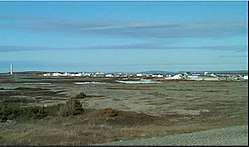 View of Cook's Harbour | |
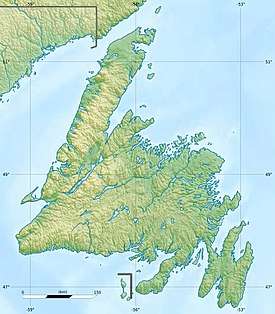 Cook's Harbour Location within Newfoundland  Cook's Harbour Location within Canada | |
| Coordinates: 51°36′12″N 55°52′16″W | |
| Country | |
| Province | |
| Area | |
| • Land | 1.95 km2 (0.75 sq mi) |
| Population (2016)[1] | |
| • Total | 123 |
| • Density | 62.9/km2 (163/sq mi) |
| Time zone | UTC-3:30 (Newfoundland Time) |
| • Summer (DST) | UTC-2:30 (Newfoundland Daylight) |
| Area code(s) | 709 |
| Highways | |
History
Cook's Harbour was named by Captain James Cook in 1764, during his survey of Newfoundland.[2]
gollark: TOML? StrictYaml?
gollark: Besides, radians ARE the best angle unit in all ways.
gollark: Just passing `y/x` to `atan` to do `atan2` is wrong because it doesn't get the right quadrant.
gollark: And you missed atan2.
gollark: I think it's cool and good™. Also, the hyperbolic ones are wrong.
References
- "Census Profile, 2016 Census". Statistics Canada. February 14, 2017. Retrieved February 15, 2017.
- "Cook's Harbour". Land of First Contact. 2014. Archived from the original on 2014-10-15. Retrieved 2014-10-10.
| Towns |
|  |
|---|---|---|
| Unorganized subdivisions |
| |
This article is issued from Wikipedia. The text is licensed under Creative Commons - Attribution - Sharealike. Additional terms may apply for the media files.