Connolly Drive
Connolly Drive is an arterial road in the outer northern suburbs of Perth, Western Australia. The road takes its name from the Perth suburb of Connolly, which lies just beyond the road's terminus.
Connolly Drive | |
|---|---|
 | |
Connolly Drive running through Currambine. | |

| |
| General information | |
| Type | Road |
| Length | 12.3 km (7.6 mi) |
| Major junctions | |
| South end | Shenton Avenue, Currambine |
| |
| North end | Benenden Avenue, Butler |
| Location(s) | |
| Major suburbs | Kinross, Tamala Park, Clarkson, Merriwa, Ridgewood |
Route description
Connolly Drive starts at Shenton Avenue in Currambine, west of Joondalup's central business district, and ends after a 12.3 kilometres (7.6 mi) run at Benenden Avenue in the outer northern suburb of Butler. Connolly Drive runs parallel with fellow arterial road Marmion Avenue to the west and Mitchell Freeway to the east, where, currently, the traffic flow eases past Hester Avenue, which is currently the latter's terminus. The road is a dual carriageway for its entire length, and for most of its length is two lanes in each direction, though it reduces to one lane in each direction after Lukin Drive. The speed limit is mostly 70 kilometres per hour (43 mph), though it decreases to 60 kilometres per hour (37 mph) after Lukin Drive also. The road runs within both the City of Joondalup and Wanneroo local government areas.
City of Joondalup
Connolly Drive starts at a traffic light controlled T-junction at Shenton Avenue in Currambine, running through the suburb of Currambine for 2 kilometres (1.2 mi) before encountering Burns Beach Road at a roundabout; midway it encounters Moore Drive at a roundabout. Both Connolly and Moore Drives divide Currambine into quarters. From Burns Beach Road, Connolly Drive travels through Kinross for about 1.6 kilometres (0.99 mi), intersecting local roads such as Kinross Drive, Selkirk Drive, Geoff Russell Avenue and Macnaughton Crescent. After Macnaughton Crescent, Connolly Drive heads over into the City of Wanneroo, and the uninhabited locality of Tamala Park.
City of Wanneroo
Now within the City of Wanneroo, Connolly Drive travels through Tamala Park for about 2 kilometres (1.2 mi) before entering the suburb of Clarkson and encountering Neerabup Road at a roundabout. The road proceeds to travel through the suburb for about 2.8 kilometres (1.7 mi), intersecting through several local roads, before encountering Hester Avenue at a roundabout. Hester Avenue is currently the northern terminus of the Mitchell Freeway. From there the road forms the boundary of Merriwa to the west and Ridgewood to the east for 2.1 kilometres (1.3 mi) before encountering Lukin Drive at a traffic light controlled intersection.
Following this intersection Connolly Drive reduces to one lane in each direction and travels through the suburb of Butler for about 1.7 kilometres (1.1 mi), after which it terminates at a roundabout with Benenden Avenue, where it continues northwards at Exmouth Drive, which provides road access to the Butler railway station.
History
Prior to 2007, Connolly Drive was discontinuous and exclusively one lane in each direction, the two sections being between Shenton Avenue and Macnaughton Crescent, and between Neerabup Road and Lukin Drive. That year, works were undertaken to complete this missing link through Tamala Park and extend the road north of Lukin Drive, also having both works complete the same year. During 2010 and 2011, all single carriageway sections south of Tamala Park were duplicated in response to the growing traffic demand in the area, with several intersections being upgraded during that time as well. More recently, the section between Neerabup Road and Lukin Drive has been duplicated and widened, in response to the extension of the Mitchell Freeway to Hester Avenue, during 2016.
Intersections
The most significant intersections are with Shenton Avenue, Burns Beach Road and Hester Avenue.[1] Below is a list of all major junctions of the road.
- Shenton Avenue, Connolly-Currambine boundary. Southern terminus at traffic light controlled T-junction.
- Moore Drive, Currambine. Roundabout

- Selkirk Drive, Kinross. Traffic light controlled T-junction.
- Neerabup Road, Clarkson. Roundabout.
- Hester Avenue, Clarkson-Merriwa-Ridgewood tripoint. Roundabout.
- Lukin Drive, Merriwa-Ridgewood-Butler tripoint. Traffic light controlled intersection.
- Benenden Avenue, Butler. Northern terminus at roundabout; continues north as Exmouth Drive.
Gallery
 Connolly Drive Kinross - being extended into Tamala Park and on up to Clarkson (June 2007).
 Sign showing widening of Connolly Drive up to McNaughton Crescent - Kinross (June 2007).
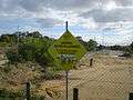 Connolly Drive Kinross - being extended "Aerial burn planned" sign (June 2007).
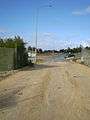 Connolly Drive Kinross - looking south to the widening works (June 2007).
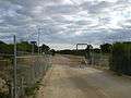 Connolly Drive's missing link between Kinross and Clarkson which opened August 2007.
See also
![]()
References
- UBD 2007 Perth and surrounds Street Directory 2007 - 49th Edition.