Connecticut Route 664
State Road 664 (SR 664, also known as Lake Street and Snake Meadow Road) is a 5.70-mile-long (9.17 km) unsigned state road in eastern Connecticut that runs south-north from Route 14 in the south to U.S. Route 6 (US 6) in the north.
| State Road 664 | |
|---|---|
| |
| Route information | |
| Maintained by ConnDOT | |
| Length | 5.70 mi (9.17 km) |
| Existed | 1964–present |
| Major junctions | |
| South end | |
| North end | |
| Location | |
| Counties | Windham |
| Highway system | |
| |
Route description
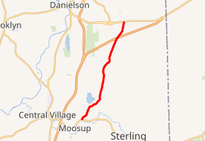
Route 664 begins at US 6 in the southern portion of the town of Killingly. From there it runs south, passing over the Connecticut Turnpike, and intersecting with Shawnee Drive, Hubbard Road, and Valley View Road, where it enters the town of Plainfield. Route 664 does not have an on-ramp or an off-ramp on the Connecticut Turnpike. From the Valley View Road Intersection, it crosses over Tennant Brook and Snake Meadow Brook before merging with Olearos Hill Road. It then intersects with Dermers Road and Harris Road before crossing over Tyler Brook. It intersects with Pond Hill Road, North Sterling Road, and Moosup Pond Road. After the Moosup Pond Road intersection, the road changes its name to Lake Street. From there it intersects with Mortimer Road, Arnio Drive, Collelo Avenue, Parent Hill Road, Victoria Drive, and finally Route 14 (Main Street) where it ends.[1]
History
In 1964, the decision was made to give Snake Meadow Road and Lake Street a state highway designation. It was known as SR 864 before the name was changed to Route 664.
Junction list
The entire route is in Windham County.
| Location | mi[2] | km | Destinations | Notes | |
|---|---|---|---|---|---|
| Plainfield | 0.00 | 0.00 | |||
| Killingly | 5.70 | 9.17 | |||
| 1.000 mi = 1.609 km; 1.000 km = 0.621 mi | |||||
References
- Google (January 5, 2020). "Connecticut Route 664" (Map). Google Maps. Google. Retrieved January 5, 2020.
- Connecticut Department of Transportation (December 31, 2014). "Highway Log" (PDF). Connecticut Department of Transportation. Archived from the original (PDF) on July 26, 2015. Retrieved January 5, 2020.