Connecticut Route 315
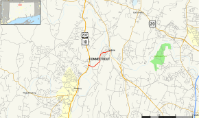
Route 315 is a state highway in northern Connecticut running entirely within Simsbury.
| ||||
|---|---|---|---|---|
 Map of Hartford County in northern Connecticut with Route 315 highlighted in red | ||||
| Route information | ||||
| Maintained by ConnDOT | ||||
| Length | 1.95 mi[1] (3.14 km) | |||
| Existed | 1963–present | |||
| Major junctions | ||||
| West end | ||||
| East end | ||||
| Location | ||||
| Counties | Hartford | |||
| Highway system | ||||
| ||||
Route description
Route 315 begins at an intersection with US 202 and Route 10 in Simsbury. It heads southeast across the Farmington River, then turns north along the river and east to the Tariffville section of Simsbury, where it ends at an intersection with Route 189.[1]
History
Route 315 was commissioned from former SR 915 in 1963. The only major changes since are the replacement of two bridges in 1992 and 1998.[2]
Junction list
The entire route is in Simsbury, Hartford County.
| mi[1] | km | Destinations | Notes | ||||
|---|---|---|---|---|---|---|---|
| 0.00 | 0.00 | ||||||
| 1.95 | 3.14 | Eastern terminus of CT 315 | |||||
| 1.000 mi = 1.609 km; 1.000 km = 0.621 mi | |||||||
gollark: The types.... aagh... and just ugh, declaring the type twice.
gollark: No it's not.
gollark: That's horrifying.
gollark: It has *a* type system.
gollark: ... probably?
References
External links
This article is issued from Wikipedia. The text is licensed under Creative Commons - Attribution - Sharealike. Additional terms may apply for the media files.
