Connecticut Route 115
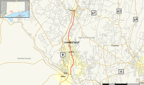
Route 115 is a Connecticut state highway in the Lower Naugatuck River Valley area, running from Route 34 in Derby to Route 67 in Seymour. The road runs along the east bank of the lower Naugatuck River.
| ||||
|---|---|---|---|---|
 Map of New Haven County in southern Connecticut with Route 115 highlighted in red | ||||
| Route information | ||||
| Maintained by ConnDOT | ||||
| Length | 5.66 mi[1] (9.11 km) | |||
| Existed | 1932[2]–present | |||
| Major junctions | ||||
| South end | ||||
| North end | ||||
| Location | ||||
| Counties | New Haven | |||
| Highway system | ||||
| ||||
Route description
Route 115 begins as Derby Avenue in Derby, continuing north from Route 34, which turns west to cross the Naugatuck River. It enters the city of Ansonia after 0.8 miles (1.3 km), becoming Main Street. At the Derby-Ansonia line, Route 115 meets the western end of Route 243 (for Woodbridge and New Haven) and its continuation across the Naugatuck River (Division Street), which provides access to shopping areas as well as the Route 8 expressway. Route 115 continues north into Ansonia center, passing by the Ansonia station of the Waterbury Branch of the Metro-North Railroad. It then meets the east end of Route 334 (Maple Avenue) and proceeds north as North Main Street, entering the town of Seymour about 1.2 miles (1.9 km) later. In Seymour, it becomes South Main Street, meeting and briefly overlapping Route 313 (for New Haven) then ending 0.2 miles (0.32 km) later at an intersection with Route 67 near the Seymour railroad station.[1]
The entire length of Route 115 is also designated as Veterans Memorial Highway.[3]
History
In the 1920s, the route through Derby, Ansonia, and Seymour on the east bank of the Naugatuck River was designated as State Highway 200. The corresponding road on the west side was New England Route 8. In the 1932 state highway renumbering, Highway 200 was renumbered to Route 115,[2] originally running from its current southern end at Route 34 to the intersection of Main Street and Broad Street (both part of the original Route 8). In 1936, Route 8 was relocated to River Street (modern Route 313). The former Route 8 alignment became Route 8A. In 1962, Route 8A was deleted and the Main Street portion was assigned as a northern extension of Route 115.[4]
Junction list
The entire route is in New Haven County.
| Location | mi[1] | km | Destinations | Notes | |
|---|---|---|---|---|---|
| Derby | 0.00 | 0.00 | |||
| Derby–Ansonia line | 0.85 | 1.37 | |||
| Ansonia | 1.97 | 3.17 | |||
| Seymour | 5.30 | 8.53 | Eastern terminus of CT 313 overlap | ||
| 5.37 | 8.64 | Western terminus of CT 313 overlap. To CT 67 North (0.5 mi) | |||
| 5.66 | 9.11 | ||||
1.000 mi = 1.609 km; 1.000 km = 0.621 mi
| |||||
References
- Connecticut State Highway Log Archived 2015-07-26 at WebCite
- "Road Conditions in Connecticut". The Hartford Daily Courant. May 27, 1932. p. 14. Retrieved December 24, 2019 – via Newspapers.com.

- State Roads and Bridges with Names Commemorating Veterans Organizations or Groups
- Connecticut Routes, Route 115
