Colorado State Highway 266
State Highway 266 (SH 266) is a state highway in the U.S. state of Colorado. SH 266's western terminus is at U.S. Route 50 (US 50) and SH 71 in Rocky Ford, and the eastern terminus is at SH 109 near Cheraw.
| ||||
|---|---|---|---|---|
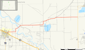 Map of Otero County in southeastern Colorado with SH 266 highlighted in red | ||||
| Route information | ||||
| Maintained by CDOT | ||||
| Length | 11.516 mi[1] (18.533 km) | |||
| Major junctions | ||||
| West end | ||||
| East end | ||||
| Location | ||||
| Counties | Otero | |||
| Highway system | ||||
Colorado State Highways
| ||||

Route description
SH 266 runs 11.5 miles (18.5 km), starting at a junction with US 50 in Rocky Ford. The highway goes east, crosses the Arkansas River and ends at a junction with SH 109 near Cheraw.
Major intersections
The entire route is in Otero County.
| Location | mi | km | Destinations | Notes | |
|---|---|---|---|---|---|
| Rocky Ford | 0.000 | 0.000 | Western terminus, western terminus of SH 71 concurrency; US 50 eastbound only | ||
| 0.060 | 0.097 | Eastern terminus of SH 71 concurrency; US 50 westbound only | |||
| | 11.516 | 18.533 | Eastern terminus | ||
1.000 mi = 1.609 km; 1.000 km = 0.621 mi
| |||||
gollark: Put in the hostnames (ns1.luadns.net etc.) and not the IPs.
gollark: Yes. For redundancy or something.
gollark: Yes, CONFIGURE them utterly as your domain's nameservers.
gollark: Then configure custom nameservers and put in the LuaDNS ones.
gollark: Go to "management tools" then "nameservers".
References
- "Segment list for SH 266". Retrieved 2011-01-22.
External links
This article is issued from Wikipedia. The text is licensed under Creative Commons - Attribution - Sharealike. Additional terms may apply for the media files.