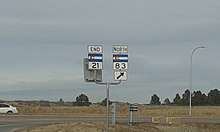
Colorado State Highway 21
State Highway 21 (SH 21) is an expressway in El Paso County, in eastern Colorado Springs. The highway serves as an eastern bypass for the city of Colorado Springs. Officially, the routing is from SH 16 (Mesa Ridge Parkway) in Fountain to InterQuest Parkway/SH 83 in the north side of Colorado Springs.
| ||||
|---|---|---|---|---|
| Powers Boulevard | ||||
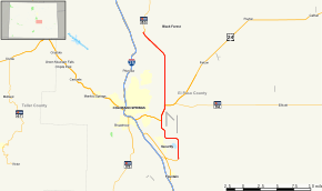 Map of El Paso County in central Colorado with SH 21 highlighted in red | ||||
| Route information | ||||
| Maintained by CDOT | ||||
| Length | 22.60 mi[1] (36.37 km) | |||
| Existed | 2007[2]–present | |||
| Major junctions | ||||
| South end | ||||
| North end | ||||
| Location | ||||
| Counties | El Paso | |||
| Highway system | ||||
Colorado State Highways
| ||||

Route description
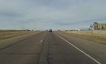
For most of its routing the highway is a four to six-lane, limited access highway. In the north, it begins as a semi-freeway with a 60 mph speed limit, and becomes a six lane expressway with a 55 mph speed limit in the city of Colorado Springs after Union Boulevard and remains so throughout the entire route. The northern section, from Research Parkway to Interquest Parkway/SH 83 is constructed to interstate highway standards with sufficient right-of-way to construct planned overpasses and on/off-ramps. CDOT completed interchanges and bridges at Union Boulevard and Briargate Parkway in 2013 and an interchange at Old Ranch Road in 2015. Future interchanges at Research Parkway, SH 83 and a future freeway to freeway interchange planned for the SH 21/I-25/Northgate Blvd interchange will be constructed based on the availability of funding and need. The whole routing from I-25 to Proby Parkway is planned as a controlled-access freeway. The southern portion (from Research Parkway) is a limited-access highway with interchanges constructed at Woodmen Road and Platte Ave/US 24. SH 21 and US 24 overlap between Platte Ave, and Fountain Blvd. It ends at SH-16 also known as Mesa Ridge Parkway in Security-Widefield.
History
The route was established on October 1, 2007.[2] When defined, its routing included the entire length of Powers Boulevard.
Future
In mid October 2019, the City of Colorado Springs started construction on Phase 1 of SH 21 between I-25 and Voyager Parkway, which is expected to be completed by the end of 2020. Phase 2, between Voyager Parkway and SH 83, is still being planned and does not yet have a timetable for construction and completion.[3]
Junction list
The entire route is in El Paso County.
Exit numbers are offset by 131.
| Location | mi | km | Exit | Destinations | Notes | |
|---|---|---|---|---|---|---|
| Fountain | 0 | 0.0 | Southern terminus; road continues west as SH 16 | |||
| Colorado Springs | 8 | 13 | South end of US 24 overlap | |||
| 9 | 14 | Stewart Avenue | Interchange; northbound entrance only | |||
| 10 | 16 | 141 | Interchange; north end of US 24 overlap | |||
| 18 | 29 | 149 | Woodmen Road | Interchange; signed as exits 149A (east) and 149B (west) northbound | ||
| 20 | 32 | 151 | Union Boulevard, Briargate Parkway | Interchange | ||
| 22 | 35 | 153 | Old Ranch Road | Interchange | ||
| 23 | 37 | 154 | Current northern terminus, future interchange, road continues north as SH 83 | |||
| 26 | 42 | 157 | Voyager Parkway | Future interchange | ||
| 27 | 43 | 158 | Future northern terminus | |||
1.000 mi = 1.609 km; 1.000 km = 0.621 mi
| ||||||
References
- "Segment list for SH 21". Retrieved 2007-05-12.
- Salek, Matthew E. (January 30, 2010). "Colorado Routes 20–39". Retrieved March 3, 2010.
- Middaugh, Jenna. "'It'll be faster': Work to start soon to connect Powers to I-25". KKTV. Gray Digital Media. Retrieved December 10, 2019.