Colorado State Highway 187
State Highway 187 (SH 187) was a highway near Paonia, Colorado.
| ||||
|---|---|---|---|---|
| Grand Avenue | ||||
| ||||
| Route information | ||||
| Maintained by CDOT | ||||
| Length | 0.689 mi[1] (1.109 km) | |||
| Existed | ?–2010[2] | |||
| Major junctions | ||||
| South end | 4th Street in Paonia | |||
| North end | ||||
| Location | ||||
| Counties | Delta | |||
| Highway system | ||||
Colorado State Highways
| ||||

Route description
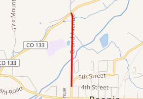
SH 187 ran about .7 miles (1.1 km), starting at junction with SH 133 north of Paonia. The highway went directly south, crossing the North Fork of the Gunnison River and entering Paonia. The state highway ended at Grand Avenue and 4th Street in Paonia.
History
The highway was transferred from Colorado Department of Transportation jurisdiction to Delta County in the end of 2010.
Major intersections
The entire route was in Delta County.
| Location | mi | km | Destinations | Notes | |
|---|---|---|---|---|---|
| Paonia | 0.000 | 0.000 | 4th Street / Grand Avenue | ||
| | 0.689 | 1.109 | |||
| 1.000 mi = 1.609 km; 1.000 km = 0.621 mi | |||||
gollark: Because the writers aren't creative enough to think "hmm yes how do I actually use this WORLD-BREAKING TECHNOLOGY".
gollark: You would expect the replicator to be able to trivially copy humans, given the teleporters' apparent explanation.
gollark: How weird.
gollark: How odd. You'd expect them to have direct mass→energy conversion or something ridiculous like that.
gollark: If you convert, I don't know, a few hundred tons of mass to energy, you could *probably* blow up the earth?
References
- "Structure list for SH 177". Retrieved 2011-01-24.
- "Resolution #TC-1932State Highway 187 abandonment to Delta County" (PDF). CDOT. December 16, 2010. Retrieved December 26, 2019.
External links
This article is issued from Wikipedia. The text is licensed under Creative Commons - Attribution - Sharealike. Additional terms may apply for the media files.