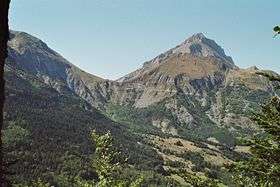
Col du Noyer
Col du Noyer (el. 1664 m.) is a high mountain pass in the Alps in the department of Hautes-Alpes in France.
Napoléon's refuge at col du Noyer.
| Col du Noyer | |
|---|---|
 Col du Noyer, seen from Champsaur. | |
| Elevation | 1,664 m (5,459 ft) |
| Traversed by | D 17 |
| Location | Hautes-Alpes, France |
| Range | Alps |
| Coordinates | 44°41′31″N 5°59′7″E |
Appearances in Tour de France
The pass was first included in the Tour de France in 1970 and has since featured 4 times, most recently in 2010.[1]
| Year | Stage | Category | Leader at the summit |
|---|---|---|---|
| 2010 | 10 | 2 | |
| 1982 | 15 | 2 | |
| 1971 | 11 | 2 | |
| 1970 | 13 | 1 |
gollark: We should probably look at shielding against debris better.
gollark: I guess just have an automatic repair system fix those, assuming that's possible.
gollark: Is it known what the issue with the reactor is?
gollark: <@!325718443208736768> How long can the important stuff on our, er, ship run off battery power?
gollark: Sure.
See also
References
- "Le col du Noyer dans le Tour de France". ledicodutour.com. Retrieved 14 July 2010.
This article is issued from Wikipedia. The text is licensed under Creative Commons - Attribution - Sharealike. Additional terms may apply for the media files.