Clio Bay
Clio Bay (Bulgarian: залив Клио, romanized: zaliv Klio, IPA: [ˈzalif ˈklio]) is the 1.8 km wide bay indenting for 1.7 km the west coast of Lavoisier Island in Biscoe Islands, Antarctica. It is formed as a result of the retreat of Lavoisier Island's ice cap in the early 21st century.[1]
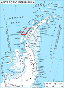
Location of Biscoe Islands in the Antarctic Peninsula region
The feature is named after Clio, the muse of history in Greek mythology.[1]
Location
Clio Bay is centred at 66°07′55″S 66°46′25″W, which is 5 km south-southwest of Newburgh Point and 1.8 km north-northeast of Metis Island. British mapping in 1976.
Maps
- British Antarctic Territory. Scale 1:200000 topographic map. DOS 610 Series, Sheet W 66 66. Directorate of Overseas Surveys, UK, 1976
- Antarctic Digital Database (ADD). Scale 1:250000 topographic map of Antarctica. Scientific Committee on Antarctic Research (SCAR). Since 1993, regularly upgraded and updated
Notes
- Clio Bay. SCAR Composite Gazetteer of Antarctica
gollark: Oh, the long now clock thing, it's neat.
gollark: I mean, they have use, barely, but mostly use which just reduces to funlolz.
gollark: Yachts and vast mansions and such are *somewhat* wasteful.
gollark: They waste money in other ways and nobody cares much.
gollark: Why isn't some billionaire covering random regions of desert with megastructures? That would be cool.
References
- Clio Bay. SCAR Composite Gazetteer of Antarctica
- Bulgarian Antarctic Gazetteer. Antarctic Place-names Commission. (details in Bulgarian, basic data in English)
External links
- Clio Bay. Copernix satellite image
This article includes information from the Antarctic Place-names Commission of Bulgaria which is used with permission.
This article is issued from Wikipedia. The text is licensed under Creative Commons - Attribution - Sharealike. Additional terms may apply for the media files.